Valencia geodata
Valencia (Córdoba) is a seat of a second-order administrative division; located in Colombia in America/Bogota (GMT-5) time zone. With population of 10,652 people, there are 291 cities with bigger population in this country. Compared to other cities in Colombia, 82.2% of cities are located further ↓South; 82.2% of cities are located further →East and 84.9% of cities have higher elevation than Valencia. Note1


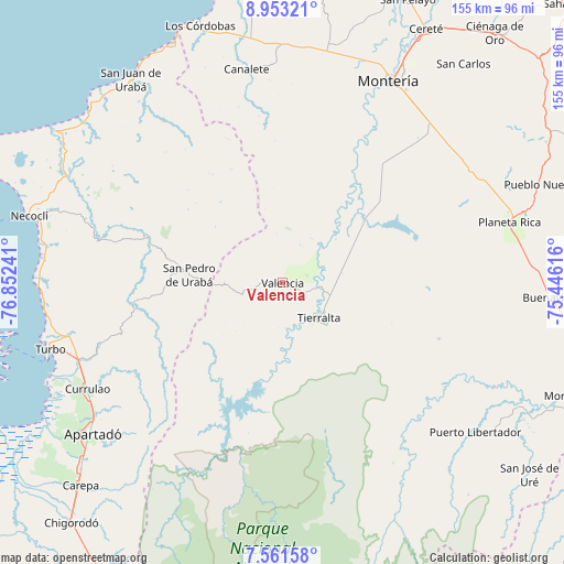
Valencia GPS coordinates[2]
8° 15' 28.836" North, 76° 8' 57.408" West
| Map corner | latitude | longitude |
|---|---|---|
| Upper-left | 8.95321°, | -76.85241° |
| Center: | 8.25801°, | -76.14928° |
| Lower-right: | 7.56158°, | -75.44616° |
| Map W x H: | 154.7×154.7 km | = 96.1×96.1mi |
| max Lat: | 13.38166° ⇑17.8% North |
| Valencia: | 8.25801° |
| min Lat: | ⇓82.2% South -4.21528° |
| min Long | Valencia | max Long |
| -81.70636° | -76.14928° | -67.06996° |
| W 17.8%⇐ | ⇒82.2% E |
Elevation
Elevation of Valencia is 62 m = 203 ft, and this is 1087.3 m = 3567 ft below average elevation for this country.
| Max E: |
3342 m = 10965 ft | 84.9% |
| Avg. | 1149.3 m = 3771 ft | |
| Valencia | 62 m = 203 ft | |
Min E: |
1 m = 3 ft | 15.1% |
See also: Colombia elevation on elevation.city.
Geographical zone
Valencia is located in North Torrid zone (between Equator and Tropic of Cancer). Distance of Equator is 918.2 km =570.5 mi to South.| Distance of | km | miles | from Valencia |
|---|---|---|---|
| North Pole | 9088.9 | 5647.6 | to North |
| Arctic Circle | 6483 | 4028.3 | to North |
| Tropic Cancer | 1687.7 | 1048.7 | to North |
| Equator | 918.2 | 570.5 | to South |


Nearby cities:
15 places around Valencia: (largest is in red/bold)
• Apartadó
67 km =41.6 mi,  231°
231°
• Arboletes
72.6 km =45.1 mi,  335°
335°
• Buenavista
73.6 km =45.7 mi,  93°
93°
• Canalete
46.9 km =29.1 mi,  352°
352°
• Canalete
59.5 km =37 mi, 350°
• Montería
61.9 km =38.5 mi,  28°
28°
• Moñitos
11 km =6.8 mi, 94°
• Necoclí
72.8 km =45.2 mi,  284°
284°
• Planeta Rica
64.4 km =40 mi,  74°
74°
• Puerto Libertador
66.8 km =41.5 mi,  127°
127°
• San Carlos
72.2 km =44.9 mi,  41°
41°
• San Juan de Urabá
69.7 km =43.3 mi,  323°
323°
• San Pedro de Urabá
25.1 km =15.6 mi,  274°
274°
• Tierralta
13.7 km =8.5 mi, 133°
• Turbo
66.3 km =41.2 mi,  253°
253°
Sources, notices
• [Note1] Compared only with cities in Colombia existing in our database
• [Src1] Map data: © OpenStreetMap contributors (CC-BY-SA)
• [Src2] Other city data from geonames.org with taken over terms of usage.
• [Src3] Geographical zone / Annual Mean Temperature by Robert A. Rohde @ Wikipedia
