Labranzagrande geodata
Labranzagrande (Boyacá) is a seat of a second-order administrative division; located in Colombia in America/Bogota (GMT-5) time zone. With population of 902 people, there are 961 cities with bigger population in this country. Compared to other cities in Colombia, 51.2% of cities are located further ↓South; 94.7% of cities are located further ←West and 50.1% of cities have lower elevation than Labranzagrande. Note1


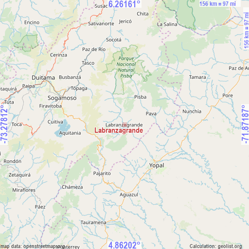
Labranzagrande GPS coordinates[2]
5° 33' 44.028" North, 72° 34' 29.964" West
| Map corner | latitude | longitude |
|---|---|---|
| Upper-left | 6.26161°, | -73.27812° |
| Center: | 5.56223°, | -72.57499° |
| Lower-right: | 4.86202°, | -71.87187° |
| Map W x H: | 155.6×155.6 km | = 96.7×96.7mi |
| max Lat: | 13.38166° ⇑48.8% North |
| Labranzagrande: | 5.56223° |
| min Lat: | ⇓51.2% South -4.21528° |
| min Long | Labranzagrande | max Long |
| -81.70636° | -72.57499° | -67.06996° |
| W 94.7%⇐ | ⇒5.3% E |
Elevation
Elevation of Labranzagrande is 1128 m = 3701 ft, and this is 21.3 m = 70 ft below average elevation for this country.
| Max E: |
3342 m = 10965 ft | 49.9% |
| Avg. | 1149.3 m = 3771 ft | |
| Labranzagrande | 1128 m = 3701 ft | |
Min E: |
1 m = 3 ft | 50.1% |
See also: Colombia elevation on elevation.city.
Geographical zone
Labranzagrande is located in North Torrid zone (between Equator and Tropic of Cancer). Distance of Equator is 618.5 km =384.3 mi to South.| Distance of | km | miles | from Labranzagrande |
|---|---|---|---|
| North Pole | 9388.6 | 5833.8 | to North |
| Arctic Circle | 6782.7 | 4214.6 | to North |
| Tropic Cancer | 1987.5 | 1235 | to North |
| Equator | 618.5 | 384.3 | to South |


Nearby cities:
15 places around Labranzagrande: (largest is in red/bold)
• Aguazul
43.4 km =27 mi,  175°
175°
• Aquitania
34.5 km =21.4 mi,  261°
261°
• Corrales
42 km =26.1 mi,  315°
315°
• Cuítiva
43.4 km =27 mi,  272°
272°
• Gámeza
37 km =23 mi, 316°
• Mongua
32.8 km =20.4 mi,  309°
309°
• Monguí
35.1 km =21.8 mi,  300°
300°
• Nunchía
42.8 km =26.6 mi,  78°
78°
• Pajarito
33.1 km =20.6 mi,  205°
205°
• Paya
18.2 km =11.3 mi,  67°
67°
• Pisba
20.5 km =12.7 mi,  28°
28°
• Recetor
42.3 km =26.3 mi, 209°
• Sogamoso
43.2 km =26.8 mi,  293°
293°
• Tópaga
35.4 km =22 mi, 308°
• Yopal
31.9 km =19.8 mi,  141°
141°
Sources, notices
• [Note1] Compared only with cities in Colombia existing in our database
• [Src1] Map data: © OpenStreetMap contributors (CC-BY-SA)
• [Src2] Other city data from geonames.org with taken over terms of usage.
• [Src3] Geographical zone / Annual Mean Temperature by Robert A. Rohde @ Wikipedia
