Yopal geodata
Yopal (Casanare) is a seat of a first-order administrative division; located in Colombia in America/Bogota (GMT-5) time zone. With population of 61,029 people, there are 64 cities with bigger population in this country. Compared to other cities in Colombia, 53.9% of cities are located further ↑North; 96.9% of cities are located further ←West and 67.8% of cities have higher elevation than Yopal. Note1


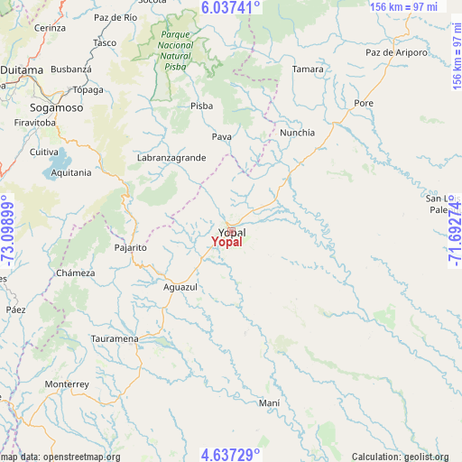
Yopal GPS coordinates[2]
5° 20' 15.9" North, 72° 23' 45.096" West
| Map corner | latitude | longitude |
|---|---|---|
| Upper-left | 6.03741°, | -73.09899° |
| Center: | 5.33775°, | -72.39586° |
| Lower-right: | 4.63729°, | -71.69274° |
| Map W x H: | 155.7×155.7 km | = 96.7×96.7mi |
| max Lat: | 13.38166° ⇑53.9% North |
| Yopal: | 5.33775° |
| min Lat: | ⇓46.1% South -4.21528° |
| min Long | Yopal | max Long |
| -81.70636° | -72.39586° | -67.06996° |
| W 96.9%⇐ | ⇒3.1% E |
Elevation
Elevation of Yopal is 338 m = 1109 ft, and this is 811.3 m = 2662 ft below average elevation for this country.
| Max E: |
3342 m = 10965 ft | 67.8% |
| Avg. | 1149.3 m = 3771 ft | |
| Yopal | 338 m = 1109 ft | |
Min E: |
1 m = 3 ft | 32.2% |
See also: Yopal elevation on elevation.city.
Geographical zone
Yopal is located in North Torrid zone (between Equator and Tropic of Cancer). Distance of Equator is 593.5 km =368.8 mi to South.| Distance of | km | miles | from Yopal |
|---|---|---|---|
| North Pole | 9413.6 | 5849.3 | to North |
| Arctic Circle | 6807.7 | 4230.1 | to North |
| Tropic Cancer | 2012.4 | 1250.4 | to North |
| Equator | 593.5 | 368.8 | to South |


Nearby cities:
15 places around Yopal: (largest is in red/bold)
• Aguazul
24.8 km =15.4 mi,  222°
222°
• Aquitania
57.6 km =35.8 mi,  290°
290°
• Chámeza
54.2 km =33.7 mi,  255°
255°
• Labranzagrande
31.9 km =19.8 mi,  321°
321°
• Maní
59.4 km =36.9 mi,  167°
167°
• Mongua
64.4 km =40 mi, 315°
• Nunchía
39.9 km =24.8 mi,  33°
33°
• Pajarito
34.3 km =21.3 mi, 261°
• Paya
32.1 km =19.9 mi,  354°
354°
• Pisba
44.1 km =27.4 mi, 346°
• Pore
62.2 km =38.6 mi,  45°
45°
• Recetor
42.2 km =26.2 mi,  253°
253°
• Tauramena
52.7 km =32.7 mi,  227°
227°
• Támara
60.5 km =37.6 mi, 25°
• Villanueva
47.9 km =29.8 mi,  97°
97°
Sources, notices
• [Note1] Compared only with cities in Colombia existing in our database
• [Src1] Map data: © OpenStreetMap contributors (CC-BY-SA)
• [Src2] Other city data from geonames.org with taken over terms of usage.
• [Src3] Geographical zone / Annual Mean Temperature by Robert A. Rohde @ Wikipedia
