Paya geodata
Paya (Boyacá) is a seat of a second-order administrative division; located in Colombia in America/Bogota (GMT-5) time zone. With population of 336 people, there are 1040 cities with bigger population in this country. Compared to other cities in Colombia, 52.6% of cities are located further ↓South; 96.7% of cities are located further ←West and 54.4% of cities have higher elevation than Paya. Note1


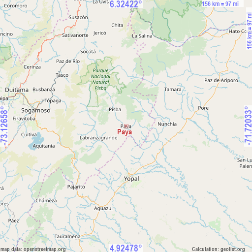
Paya GPS coordinates[2]
5° 37' 29.712" North, 72° 25' 24.42" West
| Map corner | latitude | longitude |
|---|---|---|
| Upper-left | 6.32422°, | -73.12658° |
| Center: | 5.62492°, | -72.42345° |
| Lower-right: | 4.92478°, | -71.72033° |
| Map W x H: | 155.6×155.6 km | = 96.7×96.7mi |
| max Lat: | 13.38166° ⇑47.4% North |
| Paya: | 5.62492° |
| min Lat: | ⇓52.6% South -4.21528° |
| min Long | Paya | max Long |
| -81.70636° | -72.42345° | -67.06996° |
| W 96.7%⇐ | ⇒3.3% E |
Elevation
Elevation of Paya is 984 m = 3228 ft, and this is 165.3 m = 542 ft below average elevation for this country.
| Max E: |
3342 m = 10965 ft | 54.4% |
| Avg. | 1149.3 m = 3771 ft | |
| Paya | 984 m = 3228 ft | |
Min E: |
1 m = 3 ft | 45.6% |
See also: Colombia elevation on elevation.city.
Geographical zone
Paya is located in North Torrid zone (between Equator and Tropic of Cancer). Distance of Equator is 625.4 km =388.6 mi to South.| Distance of | km | miles | from Paya |
|---|---|---|---|
| North Pole | 9381.6 | 5829.5 | to North |
| Arctic Circle | 6775.7 | 4210.2 | to North |
| Tropic Cancer | 1980.5 | 1230.6 | to North |
| Equator | 625.4 | 388.6 | to South |


Nearby cities:
15 places around Paya: (largest is in red/bold)
• Corrales
51.7 km =32.1 mi,  296°
296°
• Gámeza
46.7 km =29 mi, 295°
• Labranzagrande
18.2 km =11.3 mi,  247°
247°
• Mongua
44.3 km =27.5 mi,  288°
288°
• Monguí
48.3 km =30 mi,  282°
282°
• Nunchía
25.3 km =15.7 mi,  87°
87°
• Pajarito
48.2 km =30 mi,  219°
219°
• Pisba
13 km =8.1 mi,  327°
327°
• Pore
49 km =30.4 mi,  76°
76°
• Socha
50.9 km =31.6 mi,  324°
324°
• Socha Viejo
51.1 km =31.8 mi, 320°
• Tasco
50.6 km =31.4 mi,  308°
308°
• Támara
36.8 km =22.9 mi,  51°
51°
• Tópaga
47 km =29.2 mi, 288°
• Yopal
32.1 km =19.9 mi,  174°
174°
Sources, notices
• [Note1] Compared only with cities in Colombia existing in our database
• [Src1] Map data: © OpenStreetMap contributors (CC-BY-SA)
• [Src2] Other city data from geonames.org with taken over terms of usage.
• [Src3] Geographical zone / Annual Mean Temperature by Robert A. Rohde @ Wikipedia
