Pajarito geodata
Pajarito (Boyacá) is a seat of a second-order administrative division; located in Colombia in America/Bogota (GMT-5) time zone. With population of 1,258 people, there are 906 cities with bigger population in this country. Compared to other cities in Colombia, 55.2% of cities are located further ↑North; 92.4% of cities are located further ←West and 59.5% of cities have higher elevation than Pajarito. Note1


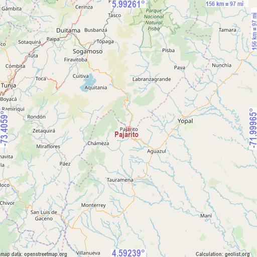
Pajarito GPS coordinates[2]
5° 17' 34.44" North, 72° 42' 9.972" West
| Map corner | latitude | longitude |
|---|---|---|
| Upper-left | 5.99261°, | -73.4059° |
| Center: | 5.2929°, | -72.70277° |
| Lower-right: | 4.59239°, | -71.99965° |
| Map W x H: | 155.7×155.7 km | = 96.7×96.7mi |
| max Lat: | 13.38166° ⇑55.2% North |
| Pajarito: | 5.2929° |
| min Lat: | ⇓44.8% South -4.21528° |
| min Long | Pajarito | max Long |
| -81.70636° | -72.70277° | -67.06996° |
| W 92.4%⇐ | ⇒7.6% E |
Elevation
Elevation of Pajarito is 793 m = 2602 ft, and this is 356.3 m = 1169 ft below average elevation for this country.
| Max E: |
3342 m = 10965 ft | 59.5% |
| Avg. | 1149.3 m = 3771 ft | |
| Pajarito | 793 m = 2602 ft | |
Min E: |
1 m = 3 ft | 40.5% |
See also: Colombia elevation on elevation.city.
Geographical zone
Pajarito is located in North Torrid zone (between Equator and Tropic of Cancer). Distance of Equator is 588.5 km =365.7 mi to South.| Distance of | km | miles | from Pajarito |
|---|---|---|---|
| North Pole | 9418.5 | 5852.4 | to North |
| Arctic Circle | 6812.7 | 4233.2 | to North |
| Tropic Cancer | 2017.4 | 1253.6 | to North |
| Equator | 588.5 | 365.7 | to South |


Nearby cities:
15 places around Pajarito: (largest is in red/bold)
• Aguazul
21.8 km =13.5 mi,  127°
127°
• Aquitania
32.1 km =19.9 mi,  321°
321°
• Berbeo
47.4 km =29.5 mi,  261°
261°
• Chámeza
20.4 km =12.7 mi,  244°
244°
• Cuítiva
43.3 km =26.9 mi, 317°
• Iza
46.9 km =29.1 mi, 319°
• Labranzagrande
33.1 km =20.6 mi,  25°
25°
• Paya
48.2 km =30 mi,  39°
39°
• Pesca
47.9 km =29.8 mi,  306°
306°
• Páez
44.1 km =27.4 mi, 241°
• Recetor
9.6 km =6 mi,  222°
222°
• San Eduardo
42.1 km =26.2 mi, 259°
• Tauramena
31 km =19.3 mi,  189°
189°
• Tota
43.2 km =26.8 mi, 313°
• Yopal
34.3 km =21.3 mi,  81°
81°
Sources, notices
• [Note1] Compared only with cities in Colombia existing in our database
• [Src1] Map data: © OpenStreetMap contributors (CC-BY-SA)
• [Src2] Other city data from geonames.org with taken over terms of usage.
• [Src3] Geographical zone / Annual Mean Temperature by Robert A. Rohde @ Wikipedia
