Nunchía geodata
Nunchía (Casanare) is a populated place; located in Colombia in America/Bogota (GMT-5) time zone. With population of 1,282 people, there are 904 cities with bigger population in this country. Compared to other cities in Colombia, 53% of cities are located further ↓South; 97.4% of cities are located further ←West and 66.2% of cities have higher elevation than Nunchía. Note1


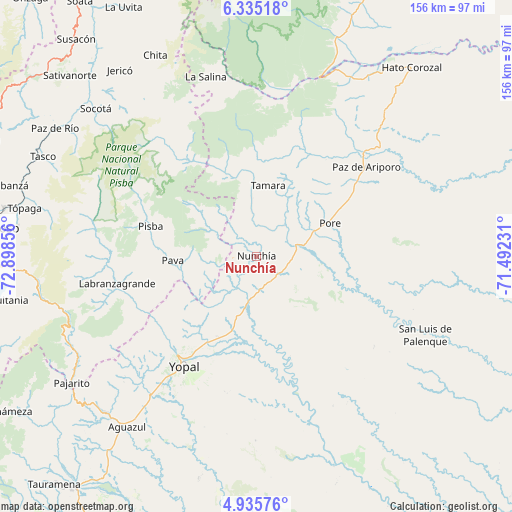
Nunchía GPS coordinates[2]
5° 38' 9.204" North, 72° 11' 43.548" West
| Map corner | latitude | longitude |
|---|---|---|
| Upper-left | 6.33518°, | -72.89856° |
| Center: | 5.63589°, | -72.19543° |
| Lower-right: | 4.93576°, | -71.49231° |
| Map W x H: | 155.6×155.6 km | = 96.7×96.7mi |
| max Lat: | 13.38166° ⇑47% North |
| Nunchía: | 5.63589° |
| min Lat: | ⇓53% South -4.21528° |
| min Long | Nunchía | max Long |
| -81.70636° | -72.19543° | -67.06996° |
| W 97.4%⇐ | ⇒2.6% E |
Elevation
Elevation of Nunchía is 396 m = 1299 ft, and this is 753.3 m = 2471 ft below average elevation for this country.
| Max E: |
3342 m = 10965 ft | 66.2% |
| Avg. | 1149.3 m = 3771 ft | |
| Nunchía | 396 m = 1299 ft | |
Min E: |
1 m = 3 ft | 33.8% |
See also: Colombia elevation on elevation.city.
Geographical zone
Nunchía is located in North Torrid zone (between Equator and Tropic of Cancer). Distance of Equator is 626.7 km =389.4 mi to South.| Distance of | km | miles | from Nunchía |
|---|---|---|---|
| North Pole | 9380.4 | 5828.7 | to North |
| Arctic Circle | 6774.5 | 4209.5 | to North |
| Tropic Cancer | 1979.3 | 1229.9 | to North |
| Equator | 626.7 | 389.4 | to South |


Nearby cities:
15 places around Nunchía: (largest is in red/bold)
• Aguazul
64.5 km =40.1 mi,  217°
217°
• La Salina
57.3 km =35.6 mi,  343°
343°
• Labranzagrande
42.8 km =26.6 mi,  258°
258°
• Pajarito
67.9 km =42.2 mi,  235°
235°
• Paya
25.3 km =15.7 mi,  267°
267°
• Paz de Ariporo
43.3 km =26.9 mi,  50°
50°
• Pisba
33.7 km =20.9 mi,  286°
286°
• Pore
24.7 km =15.3 mi,  65°
65°
• San Luis de Palenque
56.6 km =35.2 mi,  114°
114°
• Socotá
66.2 km =41.1 mi,  312°
312°
• Sácama
51.8 km =32.2 mi,  353°
353°
• Trinidad
64.2 km =39.9 mi, 113°
• Támara
21.9 km =13.6 mi,  9°
9°
• Villanueva
46.7 km =29 mi,  147°
147°
• Yopal
39.9 km =24.8 mi,  213°
213°
Sources, notices
• [Note1] Compared only with cities in Colombia existing in our database
• [Src1] Map data: © OpenStreetMap contributors (CC-BY-SA)
• [Src2] Other city data from geonames.org with taken over terms of usage.
• [Src3] Geographical zone / Annual Mean Temperature by Robert A. Rohde @ Wikipedia
