Junín geodata
Junín (Cundinamarca) is a seat of a second-order administrative division; located in Colombia in America/Bogota (GMT-5) time zone. With population of 1,499 people, there are 866 cities with bigger population in this country. Compared to other cities in Colombia, 66.8% of cities are located further ↑North; 72.3% of cities are located further ←West and 86.4% of cities have lower elevation than Junín. Note1


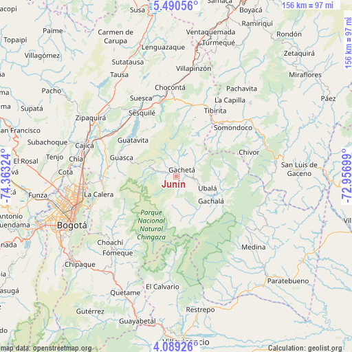
Junín GPS coordinates[2]
4° 47' 24.972" North, 73° 39' 36.396" West
| Map corner | latitude | longitude |
|---|---|---|
| Upper-left | 5.49056°, | -74.36324° |
| Center: | 4.79027°, | -73.66011° |
| Lower-right: | 4.08926°, | -72.95699° |
| Map W x H: | 155.8×155.8 km | = 96.8×96.8mi |
| max Lat: | 13.38166° ⇑66.8% North |
| Junín: | 4.79027° |
| min Lat: | ⇓33.2% South -4.21528° |
| min Long | Junín | max Long |
| -81.70636° | -73.66011° | -67.06996° |
| W 72.3%⇐ | ⇒27.7% E |
Elevation
Elevation of Junín is 2376 m = 7795 ft, and this is 1226.7 m = 4025 ft above average elevation for this country.
| Max E: |
3342 m = 10965 ft | 13.6% |
| Junín | 2376 m 7795 ft | |
| Avg. | 1149.3 m = 3771 ft | |
Min E: |
1 m = 3 ft | 86.4% |
See also: Colombia elevation on elevation.city.
Geographical zone
Junín is located in North Torrid zone (between Equator and Tropic of Cancer). Distance of Equator is 532.6 km =330.9 mi to South.| Distance of | km | miles | from Junín |
|---|---|---|---|
| North Pole | 9474.4 | 5887.1 | to North |
| Arctic Circle | 6868.5 | 4267.9 | to North |
| Tropic Cancer | 2073.3 | 1288.3 | to North |
| Equator | 532.6 | 330.9 | to South |


Nearby cities:
15 places around Junín: (largest is in red/bold)
• Gachalá
18.9 km =11.7 mi,  125°
125°
• Gachancipá
32.4 km =20.1 mi,  313°
313°
• Gachetá
4.1 km =2.5 mi,  39°
39°
• Gama
6.2 km =3.9 mi,  119°
119°
• Guasca
25.5 km =15.8 mi,  289°
289°
• Guatavita
25.1 km =15.6 mi, 310°
• Guateque
31.7 km =19.7 mi, 40°
• Guayatá
27.2 km =16.9 mi, 44°
• Machetá
32.9 km =20.4 mi,  10°
10°
• Manta
27.6 km =17.1 mi,  28°
28°
• Sesquilé
32.1 km =19.9 mi,  331°
331°
• Somondoco
33.2 km =20.6 mi,  49°
49°
• Sopó
33.5 km =20.8 mi, 292°
• Tibirita
33.8 km =21 mi, 30°
• Ubalá
14.8 km =9.2 mi,  110°
110°
Sources, notices
• [Note1] Compared only with cities in Colombia existing in our database
• [Src1] Map data: © OpenStreetMap contributors (CC-BY-SA)
• [Src2] Other city data from geonames.org with taken over terms of usage.
• [Src3] Geographical zone / Annual Mean Temperature by Robert A. Rohde @ Wikipedia
