Inzá geodata
Inzá (Cauca) is a seat of a second-order administrative division; located in Colombia in America/Bogota (GMT-5) time zone. With population of 2,972 people, there are 684 cities with bigger population in this country. Compared to other cities in Colombia, 86.7% of cities are located further ↑North; 81.4% of cities are located further →East and 69.2% of cities have lower elevation than Inzá. Note1


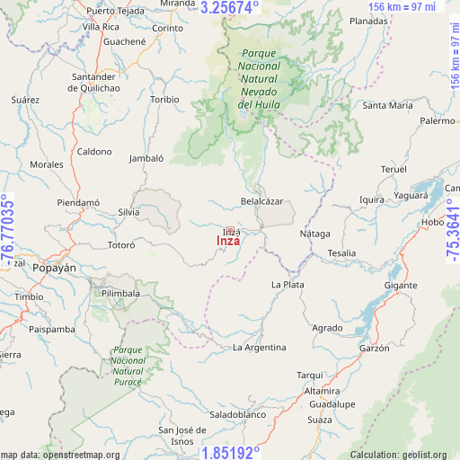
Inzá GPS coordinates[2]
2° 33' 16.272" North, 76° 4' 1.992" West
| Map corner | latitude | longitude |
|---|---|---|
| Upper-left | 3.25674°, | -76.77035° |
| Center: | 2.55452°, | -76.06722° |
| Lower-right: | 1.85192°, | -75.3641° |
| Map W x H: | 156.2×156.2 km | = 97.1×97.1mi |
| max Lat: | 13.38166° ⇑86.7% North |
| Inzá: | 2.55452° |
| min Lat: | ⇓13.3% South -4.21528° |
| min Long | Inzá | max Long |
| -81.70636° | -76.06722° | -67.06996° |
| W 18.6%⇐ | ⇒81.4% E |
Elevation
Elevation of Inzá is 1712 m = 5617 ft, and this is 562.7 m = 1846 ft above average elevation for this country.
| Max E: |
3342 m = 10965 ft | 30.8% |
| Inzá | 1712 m 5617 ft | |
| Avg. | 1149.3 m = 3771 ft | |
Min E: |
1 m = 3 ft | 69.2% |
See also: Colombia elevation on elevation.city.
Geographical zone
Inzá is located in North Torrid zone (between Equator and Tropic of Cancer). Distance of Equator is 284 km =176.5 mi to South.| Distance of | km | miles | from Inzá |
|---|---|---|---|
| North Pole | 9723 | 6041.6 | to North |
| Arctic Circle | 7117.1 | 4422.4 | to North |
| Tropic Cancer | 2321.9 | 1442.8 | to North |
| Equator | 284 | 176.5 | to South |


Nearby cities:
15 places around Inzá: (largest is in red/bold)
• Agrado
46.6 km =29 mi,  135°
135°
• Belalcázar
14.7 km =9.1 mi,  45°
45°
• Coconuco
53.1 km =33 mi,  243°
243°
• Jambaló
37.8 km =23.5 mi,  310°
310°
• La Argentina
40.9 km =25.4 mi,  166°
166°
• La Plata
26.4 km =16.4 mi,  132°
132°
• Nátaga
28.8 km =17.9 mi,  92°
92°
• Paicol
34.5 km =21.4 mi,  109°
109°
• Piendamo
52.3 km =32.5 mi,  280°
280°
• Pital
43.3 km =26.9 mi, 137°
• Silvia
35.7 km =22.2 mi, 280°
• Tesalia
38.3 km =23.8 mi,  101°
101°
• Toribío
49.8 km =30.9 mi,  333°
333°
• Totoró
37.5 km =23.3 mi,  262°
262°
• Íquira
49.2 km =30.6 mi,  77°
77°
Sources, notices
• [Note1] Compared only with cities in Colombia existing in our database
• [Src1] Map data: © OpenStreetMap contributors (CC-BY-SA)
• [Src2] Other city data from geonames.org with taken over terms of usage.
• [Src3] Geographical zone / Annual Mean Temperature by Robert A. Rohde @ Wikipedia
