La Plata geodata
La Plata (Huila) is a seat of a second-order administrative division; located in Colombia in America/Bogota (GMT-5) time zone. With population of 19,275 people, there are 187 cities with bigger population in this country. Compared to other cities in Colombia, 87.9% of cities are located further ↑North; 78% of cities are located further →East and 52.9% of cities have higher elevation than La Plata. Note1


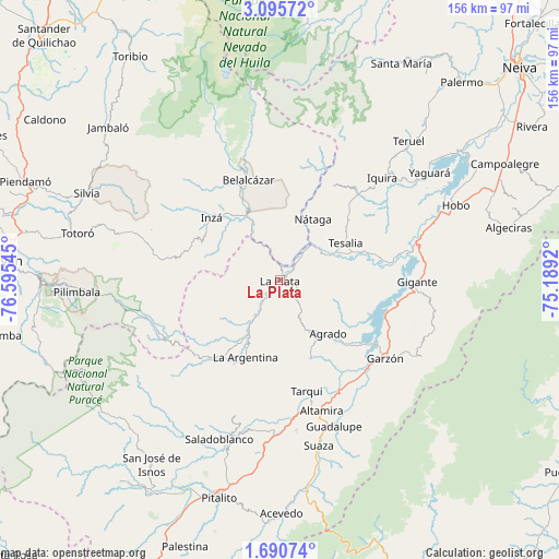
La Plata GPS coordinates[2]
2° 23' 36.276" North, 75° 53' 32.352" West
| Map corner | latitude | longitude |
|---|---|---|
| Upper-left | 3.09572°, | -76.59545° |
| Center: | 2.39341°, | -75.89232° |
| Lower-right: | 1.69074°, | -75.1892° |
| Map W x H: | 156.2×156.2 km | = 97.1×97.1mi |
| max Lat: | 13.38166° ⇑87.9% North |
| La Plata: | 2.39341° |
| min Lat: | ⇓12.1% South -4.21528° |
| min Long | La Plata | max Long |
| -81.70636° | -75.89232° | -67.06996° |
| W 22%⇐ | ⇒78% E |
Elevation
Elevation of La Plata is 1020 m = 3346 ft, and this is 129.3 m = 424 ft below average elevation for this country.
| Max E: |
3342 m = 10965 ft | 52.9% |
| Avg. | 1149.3 m = 3771 ft | |
| La Plata | 1020 m = 3346 ft | |
Min E: |
1 m = 3 ft | 47.1% |
See also: Colombia elevation on elevation.city.
Geographical zone
La Plata is located in North Torrid zone (between Equator and Tropic of Cancer). Distance of Equator is 266.1 km =165.3 mi to South.| Distance of | km | miles | from La Plata |
|---|---|---|---|
| North Pole | 9740.9 | 6052.7 | to North |
| Arctic Circle | 7135.1 | 4433.5 | to North |
| Tropic Cancer | 2339.8 | 1453.9 | to North |
| Equator | 266.1 | 165.3 | to South |


Nearby cities:
15 places around La Plata: (largest is in red/bold)
• Agrado
20.2 km =12.6 mi,  138°
138°
• Altamira
38.6 km =24 mi,  162°
162°
• Belalcázar
29.5 km =18.3 mi,  342°
342°
• Elías
42.8 km =26.6 mi,  187°
187°
• Garzón
36.7 km =22.8 mi,  126°
126°
• Gigante
38.3 km =23.8 mi,  91°
91°
• Inzá
26.4 km =16.4 mi,  312°
312°
• La Argentina
23.8 km =14.8 mi,  204°
204°
• Nátaga
19.1 km =11.9 mi,  29°
29°
• Oporapa
42.7 km =26.5 mi, 195°
• Paicol
14.5 km =9 mi,  64°
64°
• Pital
17.2 km =10.7 mi,  145°
145°
• Tarqui
32.1 km =19.9 mi,  166°
166°
• Tesalia
20.8 km =12.9 mi, 60°
• Íquira
40.3 km =25 mi,  45°
45°
Sources, notices
• [Note1] Compared only with cities in Colombia existing in our database
• [Src1] Map data: © OpenStreetMap contributors (CC-BY-SA)
• [Src2] Other city data from geonames.org with taken over terms of usage.
• [Src3] Geographical zone / Annual Mean Temperature by Robert A. Rohde @ Wikipedia
