Agrado geodata
Agrado (Huila) is a seat of a second-order administrative division; located in Colombia in America/Bogota (GMT-5) time zone. With population of 4,530 people, there are 541 cities with bigger population in this country. Compared to other cities in Colombia, 88.5% of cities are located further ↑North; 74.4% of cities are located further →East and 58.9% of cities have higher elevation than Agrado. Note1


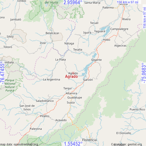
Agrado GPS coordinates[2]
2° 15' 26.1" North, 75° 46' 17.112" West
| Map corner | latitude | longitude |
|---|---|---|
| Upper-left | 2.95964°, | -76.47455° |
| Center: | 2.25725°, | -75.77142° |
| Lower-right: | 1.55452°, | -75.0683° |
| Map W x H: | 156.2×156.2 km | = 97.1×97.1mi |
| max Lat: | 13.38166° ⇑88.5% North |
| Agrado: | 2.25725° |
| min Lat: | ⇓11.5% South -4.21528° |
| min Long | Agrado | max Long |
| -81.70636° | -75.77142° | -67.06996° |
| W 25.6%⇐ | ⇒74.4% E |
Elevation
Elevation of Agrado is 844 m = 2769 ft, and this is 305.3 m = 1002 ft below average elevation for this country.
| Max E: |
3342 m = 10965 ft | 58.9% |
| Avg. | 1149.3 m = 3771 ft | |
| Agrado | 844 m = 2769 ft | |
Min E: |
1 m = 3 ft | 41.1% |
See also: Colombia elevation on elevation.city.
Geographical zone
Agrado is located in North Torrid zone (between Equator and Tropic of Cancer). Distance of Equator is 251 km =156 mi to South.| Distance of | km | miles | from Agrado |
|---|---|---|---|
| North Pole | 9756.1 | 6062.2 | to North |
| Arctic Circle | 7150.2 | 4442.9 | to North |
| Tropic Cancer | 2354.9 | 1463.3 | to North |
| Equator | 251 | 156 | to South |


Nearby cities:
15 places around Agrado: (largest is in red/bold)
• Altamira
21.7 km =13.5 mi,  184°
184°
• Elías
33.1 km =20.6 mi,  214°
214°
• Garzón
17.4 km =10.8 mi,  113°
113°
• Gigante
28.8 km =17.9 mi,  59°
59°
• Guadalupe
25.9 km =16.1 mi, 176°
• La Argentina
24.1 km =15 mi,  254°
254°
• La Plata
20.2 km =12.6 mi,  318°
318°
• Nátaga
32.1 km =19.9 mi,  352°
352°
• Oporapa
36 km =22.4 mi,  223°
223°
• Paicol
21.4 km =13.3 mi,  358°
358°
• Pital
3.8 km =2.4 mi,  285°
285°
• Suaza
31.4 km =19.5 mi, 184°
• Tarqui
17.1 km =10.6 mi,  200°
200°
• Tesalia
25.8 km =16 mi,  10°
10°
• Timaná
36.4 km =22.6 mi, 209°
Sources, notices
• [Note1] Compared only with cities in Colombia existing in our database
• [Src1] Map data: © OpenStreetMap contributors (CC-BY-SA)
• [Src2] Other city data from geonames.org with taken over terms of usage.
• [Src3] Geographical zone / Annual Mean Temperature by Robert A. Rohde @ Wikipedia
