Íquira geodata
Íquira (Huila) is a seat of a second-order administrative division; located in Colombia in America/Bogota (GMT-5) time zone. With population of 3,942 people, there are 589 cities with bigger population in this country. Compared to other cities in Colombia, 85.9% of cities are located further ↑North; 70.1% of cities are located further →East and 50.7% of cities have higher elevation than Íquira. Note1


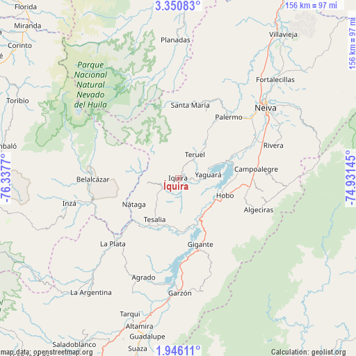
Íquira GPS coordinates[2]
2° 38' 55.212" North, 75° 38' 4.452" West
| Map corner | latitude | longitude |
|---|---|---|
| Upper-left | 3.35083°, | -76.3377° |
| Center: | 2.64867°, | -75.63457° |
| Lower-right: | 1.94611°, | -74.93145° |
| Map W x H: | 156.2×156.2 km | = 97.1×97.1mi |
| max Lat: | 13.38166° ⇑85.9% North |
| Íquira: | 2.64867° |
| min Lat: | ⇓14.1% South -4.21528° |
| min Long | Íquira | max Long |
| -81.70636° | -75.63457° | -67.06996° |
| W 29.9%⇐ | ⇒70.1% E |
Elevation
Elevation of Íquira is 1106 m = 3629 ft, and this is 43.3 m = 142 ft below average elevation for this country.
| Max E: |
3342 m = 10965 ft | 50.7% |
| Avg. | 1149.3 m = 3771 ft | |
| Íquira | 1106 m = 3629 ft | |
Min E: |
1 m = 3 ft | 49.3% |
See also: Colombia elevation on elevation.city.
Geographical zone
Íquira is located in North Torrid zone (between Equator and Tropic of Cancer). Distance of Equator is 294.5 km =183 mi to South.| Distance of | km | miles | from Íquira |
|---|---|---|---|
| North Pole | 9712.6 | 6035.1 | to North |
| Arctic Circle | 7106.7 | 4415.9 | to North |
| Tropic Cancer | 2311.4 | 1436.2 | to North |
| Equator | 294.5 | 183 | to South |


Nearby cities:
15 places around Íquira: (largest is in red/bold)
• Algeciras
37.9 km =23.5 mi,  111°
111°
• Belalcázar
37.6 km =23.4 mi,  269°
269°
• Campoalegre
34.8 km =21.6 mi,  83°
83°
• Gigante
30.7 km =19.1 mi,  161°
161°
• Hobo
21.8 km =13.5 mi, 109°
• La Plata
40.3 km =25 mi,  225°
225°
• Nátaga
22.6 km =14 mi,  238°
238°
• Paicol
27.1 km =16.8 mi,  215°
215°
• Palermo
34.8 km =21.6 mi,  39°
39°
• Rivera
44.4 km =27.6 mi,  71°
71°
• Santa María
32.7 km =20.3 mi,  9°
9°
• Santa María
33.5 km =20.8 mi,  357°
357°
• Teruel
12.8 km =8 mi, 35°
• Tesalia
20.9 km =13 mi,  210°
210°
• Yaguará
13.1 km =8.1 mi, 82°
Sources, notices
• [Note1] Compared only with cities in Colombia existing in our database
• [Src1] Map data: © OpenStreetMap contributors (CC-BY-SA)
• [Src2] Other city data from geonames.org with taken over terms of usage.
• [Src3] Geographical zone / Annual Mean Temperature by Robert A. Rohde @ Wikipedia
