Doima geodata
Doima (Tolima) is a populated place; located in Colombia in America/Bogota (GMT-5) time zone. With population of 2,808 people, there are 700 cities with bigger population in this country. Compared to other cities in Colombia, 72.5% of cities are located further ↑North; 53.5% of cities are located further →East and 62.2% of cities have higher elevation than Doima. Note1


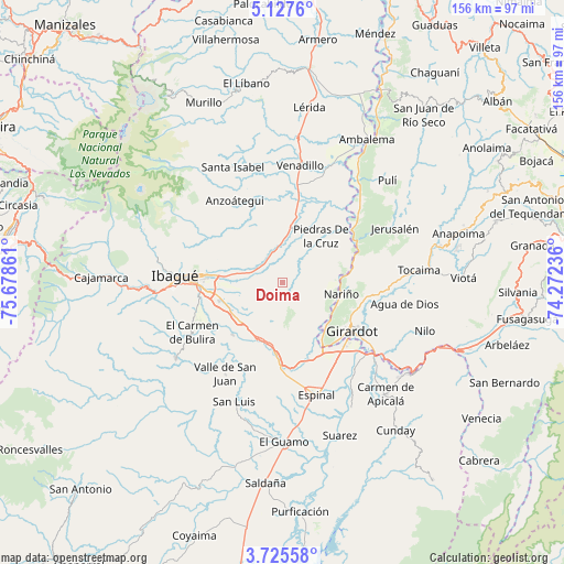
Doima GPS coordinates[2]
4° 25' 36.912" North, 74° 58' 31.728" West
| Map corner | latitude | longitude |
|---|---|---|
| Upper-left | 5.1276°, | -75.67861° |
| Center: | 4.42692°, | -74.97548° |
| Lower-right: | 3.72558°, | -74.27236° |
| Map W x H: | 155.9×155.9 km | = 96.9×96.9mi |
| max Lat: | 13.38166° ⇑72.5% North |
| Doima: | 4.42692° |
| min Lat: | ⇓27.5% South -4.21528° |
| min Long | Doima | max Long |
| -81.70636° | -74.97548° | -67.06996° |
| W 46.5%⇐ | ⇒53.5% E |
Elevation
Elevation of Doima is 603 m = 1978 ft, and this is 546.3 m = 1792 ft below average elevation for this country.
| Max E: |
3342 m = 10965 ft | 62.2% |
| Avg. | 1149.3 m = 3771 ft | |
| Doima | 603 m = 1978 ft | |
Min E: |
1 m = 3 ft | 37.8% |
See also: Colombia elevation on elevation.city.
Geographical zone
Doima is located in North Torrid zone (between Equator and Tropic of Cancer). Distance of Equator is 492.2 km =305.8 mi to South.| Distance of | km | miles | from Doima |
|---|---|---|---|
| North Pole | 9514.8 | 5912.2 | to North |
| Arctic Circle | 6908.9 | 4293 | to North |
| Tropic Cancer | 2113.7 | 1313.4 | to North |
| Equator | 492.2 | 305.8 | to South |


Nearby cities:
15 places around Doima: (largest is in red/bold)
• Alvarado
15.9 km =9.9 mi,  9°
9°
• Anzoátegui
26.2 km =16.3 mi,  329°
329°
• Chicoral
23.5 km =14.6 mi,  181°
181°
• Coello
17.6 km =10.9 mi,  150°
150°
• Espinal
32.5 km =20.2 mi,  161°
161°
• Flandes
23.3 km =14.5 mi,  130°
130°
• Girardot City
23.3 km =14.5 mi, 126°
• Guataquí
22.9 km =14.2 mi,  64°
64°
• Ibagué
28.5 km =17.7 mi,  272°
272°
• Nariño
16.7 km =10.4 mi,  101°
101°
• Payandé
19.7 km =12.2 mi,  223°
223°
• Piedras
16.8 km =10.4 mi,  39°
39°
• Ricaurte
28.5 km =17.7 mi,  124°
124°
• Valle de San Juan
29.9 km =18.6 mi,  211°
211°
• Venadillo
32.9 km =20.4 mi, 8°
Sources, notices
• [Note1] Compared only with cities in Colombia existing in our database
• [Src1] Map data: © OpenStreetMap contributors (CC-BY-SA)
• [Src2] Other city data from geonames.org with taken over terms of usage.
• [Src3] Geographical zone / Annual Mean Temperature by Robert A. Rohde @ Wikipedia
