Guatapé geodata
Guatapé (Antioquia) is a populated place; located in Colombia in America/Bogota (GMT-5) time zone. With population of 5,389 people, there are 480 cities with bigger population in this country. Compared to other cities in Colombia, 63.6% of cities are located further ↓South; 58.4% of cities are located further →East and 76% of cities have lower elevation than Guatapé. Note1


Guatapé GPS coordinates[2]
6° 14' 3.444" North, 75° 9' 48.06" West
| Map corner | latitude | longitude |
|---|---|---|
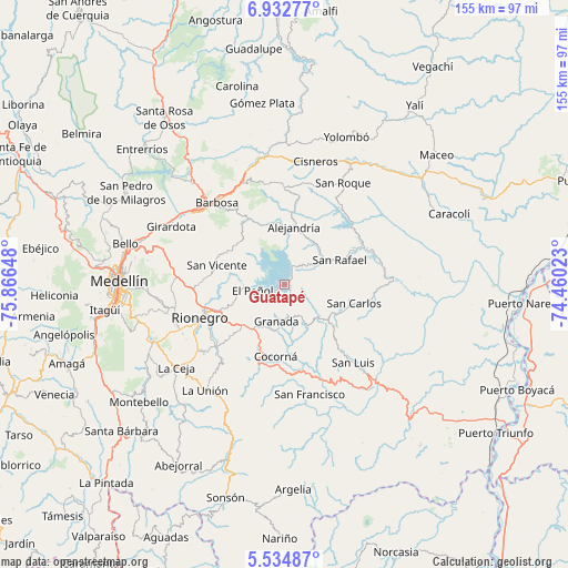
| Upper-left | 6.93277°, | -75.86648° |
| Center: | 6.23429°, | -75.16335° |
| Lower-right: | 5.53487°, | -74.46023° |
| Map W x H: | 155.4×155.4 km | = 96.6×96.6mi |
| max Lat: | 13.38166° ⇑36.4% North |
| Guatapé: | 6.23429° |
| min Lat: | ⇓63.6% South -4.21528° |
| min Long | Guatapé | max Long |
| -81.70636° | -75.16335° | -67.06996° |
| W 41.6%⇐ | ⇒58.4% E |
Elevation
Elevation of Guatapé is 1889 m = 6198 ft, and this is 739.7 m = 2427 ft above average elevation for this country.
| Max E: |
3342 m = 10965 ft | 24% |
| Guatapé | 1889 m 6198 ft | |
| Avg. | 1149.3 m = 3771 ft | |
Min E: |
1 m = 3 ft | 76% |
See also: Colombia elevation on elevation.city.
Geographical zone
Guatapé is located in North Torrid zone (between Equator and Tropic of Cancer). Distance of Equator is 693.2 km =430.7 mi to South.| Distance of | km | miles | from Guatapé |
|---|---|---|---|
| North Pole | 9313.9 | 5787.4 | to North |
| Arctic Circle | 6708 | 4168.2 | to North |
| Tropic Cancer | 1912.7 | 1188.5 | to North |
| Equator | 693.2 | 430.7 | to South |


Nearby cities:
15 places around Guatapé: (largest is in red/bold)
• Alejandría
16.1 km =10 mi,  8°
8°
• Barbosa
29.3 km =18.2 mi,  320°
320°
• Carmen de Viboral
25.4 km =15.8 mi,  228°
228°
• Cocorná
19.8 km =12.3 mi,  187°
187°
• Concepción
20.6 km =12.8 mi,  329°
329°
• Granada
10.4 km =6.5 mi, 193°
• Marinilla
20.3 km =12.6 mi,  250°
250°
• Rionegro
24.9 km =15.5 mi, 249°
• San Carlos
19.5 km =12.1 mi,  105°
105°
• San Francisco
30.8 km =19.1 mi,  167°
167°
• San Luis
28.3 km =17.6 mi,  138°
138°
• San Rafael
16.6 km =10.3 mi,  66°
66°
• San Vicente
19.7 km =12.2 mi,  286°
286°
• Santo Domingo
26.5 km =16.5 mi,  359°
359°
• Santuario
15.4 km =9.6 mi, 226°
Sources, notices
• [Note1] Compared only with cities in Colombia existing in our database
• [Src1] Map data: © OpenStreetMap contributors (CC-BY-SA)
• [Src2] Other city data from geonames.org with taken over terms of usage.
• [Src3] Geographical zone / Annual Mean Temperature by Robert A. Rohde @ Wikipedia
