Concepción geodata
Concepción (Antioquia) is a seat of a second-order administrative division; located in Colombia in America/Bogota (GMT-5) time zone. With population of 1,513 people, there are 863 cities with bigger population in this country. Compared to other cities in Colombia, 66.2% of cities are located further ↓South; 60.5% of cities are located further →East and 75% of cities have lower elevation than Concepción. Note1


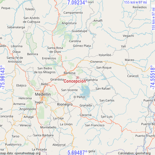
Concepción GPS coordinates[2]
6° 23' 38.688" North, 75° 15' 29.88" West
| Map corner | latitude | longitude |
|---|---|---|
| Upper-left | 7.09234°, | -75.96143° |
| Center: | 6.39408°, | -75.2583° |
| Lower-right: | 5.69487°, | -74.55518° |
| Map W x H: | 155.4×155.4 km | = 96.6×96.6mi |
| max Lat: | 13.38166° ⇑33.8% North |
| Concepción: | 6.39408° |
| min Lat: | ⇓66.2% South -4.21528° |
| min Long | Concepción | max Long |
| -81.70636° | -75.2583° | -67.06996° |
| W 39.5%⇐ | ⇒60.5% E |
Elevation
Elevation of Concepción is 1832 m = 6010 ft, and this is 682.7 m = 2240 ft above average elevation for this country.
| Max E: |
3342 m = 10965 ft | 25% |
| Concepción | 1832 m 6010 ft | |
| Avg. | 1149.3 m = 3771 ft | |
Min E: |
1 m = 3 ft | 75% |
See also: Colombia elevation on elevation.city.
Geographical zone
Concepción is located in North Torrid zone (between Equator and Tropic of Cancer). Distance of Equator is 711 km =441.8 mi to South.| Distance of | km | miles | from Concepción |
|---|---|---|---|
| North Pole | 9296.1 | 5776.3 | to North |
| Arctic Circle | 6690.2 | 4157.1 | to North |
| Tropic Cancer | 1895 | 1177.5 | to North |
| Equator | 711 | 441.8 | to South |


Nearby cities:
15 places around Concepción: (largest is in red/bold)
• Alejandría
13.1 km =8.1 mi,  98°
98°
• Barbosa
9.4 km =5.8 mi,  301°
301°
• Cisneros
24.7 km =15.3 mi,  49°
49°
• Copacabana
28.2 km =17.5 mi,  259°
259°
• Donmatías
18.2 km =11.3 mi, 304°
• Girardota
21.1 km =13.1 mi, 264°
• Granada
29 km =18 mi,  163°
163°
• Guarne
24.1 km =15 mi,  238°
238°
• Guatapé
20.6 km =12.8 mi,  149°
149°
• Marinilla
26 km =16.2 mi,  199°
199°
• San Rafael
28 km =17.4 mi,  113°
113°
• San Roque
28.2 km =17.5 mi,  69°
69°
• San Vicente
14.7 km =9.1 mi,  214°
214°
• Santo Domingo
13.5 km =8.4 mi, 49°
• Santuario
28.4 km =17.6 mi,  181°
181°
Sources, notices
• [Note1] Compared only with cities in Colombia existing in our database
• [Src1] Map data: © OpenStreetMap contributors (CC-BY-SA)
• [Src2] Other city data from geonames.org with taken over terms of usage.
• [Src3] Geographical zone / Annual Mean Temperature by Robert A. Rohde @ Wikipedia
