San Carlos geodata
San Carlos (Antioquia) is a seat of a second-order administrative division; located in Colombia in America/Bogota (GMT-5) time zone. With population of 7,742 people, there are 380 cities with bigger population in this country. Compared to other cities in Colombia, 63% of cities are located further ↓South; 54.1% of cities are located further →East and 54.2% of cities have higher elevation than San Carlos. Note1


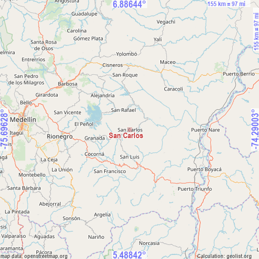
San Carlos GPS coordinates[2]
6° 11' 16.404" North, 74° 59' 35.34" West
| Map corner | latitude | longitude |
|---|---|---|
| Upper-left | 6.88644°, | -75.69628° |
| Center: | 6.18789°, | -74.99315° |
| Lower-right: | 5.48842°, | -74.29003° |
| Map W x H: | 155.4×155.4 km | = 96.6×96.6mi |
| max Lat: | 13.38166° ⇑37% North |
| San Carlos: | 6.18789° |
| min Lat: | ⇓63% South -4.21528° |
| min Long | San Carlos | max Long |
| -81.70636° | -74.99315° | -67.06996° |
| W 45.9%⇐ | ⇒54.1% E |
Elevation
Elevation of San Carlos is 989 m = 3245 ft, and this is 160.3 m = 526 ft below average elevation for this country.
| Max E: |
3342 m = 10965 ft | 54.2% |
| Avg. | 1149.3 m = 3771 ft | |
| San Carlos | 989 m = 3245 ft | |
Min E: |
1 m = 3 ft | 45.8% |
See also: Colombia elevation on elevation.city.
Geographical zone
San Carlos is located in North Torrid zone (between Equator and Tropic of Cancer). Distance of Equator is 688 km =427.5 mi to South.| Distance of | km | miles | from San Carlos |
|---|---|---|---|
| North Pole | 9319 | 5790.6 | to North |
| Arctic Circle | 6713.1 | 4171.3 | to North |
| Tropic Cancer | 1917.9 | 1191.7 | to North |
| Equator | 688 | 427.5 | to South |


Nearby cities:
15 places around San Carlos: (largest is in red/bold)
• Alejandría
26.6 km =16.5 mi,  322°
322°
• Caracolí
35.9 km =22.3 mi,  46°
46°
• Cocorná
25.7 km =16 mi,  235°
235°
• Concepción
37.2 km =23.1 mi,  308°
308°
• El Carmen
38.4 km =23.9 mi,  209°
209°
• Granada
21.8 km =13.5 mi,  256°
256°
• Guatapé
19.5 km =12.1 mi,  285°
285°
• Marinilla
38 km =23.6 mi,  267°
267°
• San Francisco
27.6 km =17.1 mi, 205°
• San Luis
16.1 km =10 mi,  180°
180°
• San Rafael
12.4 km =7.7 mi,  343°
343°
• San Roque
33.2 km =20.6 mi,  354°
354°
• San Vicente
39.2 km =24.4 mi, 286°
• Santo Domingo
37 km =23 mi,  328°
328°
• Santuario
30.5 km =19 mi, 259°
Sources, notices
• [Note1] Compared only with cities in Colombia existing in our database
• [Src1] Map data: © OpenStreetMap contributors (CC-BY-SA)
• [Src2] Other city data from geonames.org with taken over terms of usage.
• [Src3] Geographical zone / Annual Mean Temperature by Robert A. Rohde @ Wikipedia
