San Rafael geodata
San Rafael (Antioquia) is a seat of a second-order administrative division; located in Colombia in America/Bogota (GMT-5) time zone. With population of 7,245 people, there are 398 cities with bigger population in this country. Compared to other cities in Colombia, 64.4% of cities are located further ↓South; 54.8% of cities are located further →East and 53.5% of cities have higher elevation than San Rafael. Note1


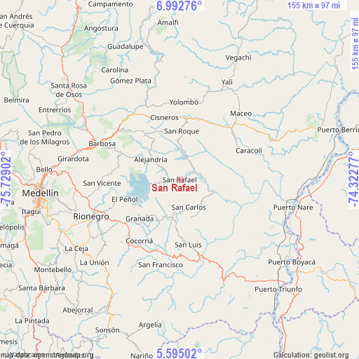
San Rafael GPS coordinates[2]
6° 17' 39.696" North, 75° 1' 33.204" West
| Map corner | latitude | longitude |
|---|---|---|
| Upper-left | 6.99276°, | -75.72902° |
| Center: | 6.29436°, | -75.02589° |
| Lower-right: | 5.59502°, | -74.32277° |
| Map W x H: | 155.4×155.4 km | = 96.6×96.6mi |
| max Lat: | 13.38166° ⇑35.6% North |
| San Rafael: | 6.29436° |
| min Lat: | ⇓64.4% South -4.21528° |
| min Long | San Rafael | max Long |
| -81.70636° | -75.02589° | -67.06996° |
| W 45.2%⇐ | ⇒54.8% E |
Elevation
Elevation of San Rafael is 994 m = 3261 ft, and this is 155.3 m = 510 ft below average elevation for this country.
| Max E: |
3342 m = 10965 ft | 53.5% |
| Avg. | 1149.3 m = 3771 ft | |
| San Rafael | 994 m = 3261 ft | |
Min E: |
1 m = 3 ft | 46.5% |
See also: Colombia elevation on elevation.city.
Geographical zone
San Rafael is located in North Torrid zone (between Equator and Tropic of Cancer). Distance of Equator is 699.9 km =434.9 mi to South.| Distance of | km | miles | from San Rafael |
|---|---|---|---|
| North Pole | 9307.2 | 5783.2 | to North |
| Arctic Circle | 6701.3 | 4164 | to North |
| Tropic Cancer | 1906.1 | 1184.4 | to North |
| Equator | 699.9 | 434.9 | to South |


Nearby cities:
15 places around San Rafael: (largest is in red/bold)
• Alejandría
15.7 km =9.8 mi,  306°
306°
• Caracolí
32.3 km =20.1 mi,  66°
66°
• Cisneros
28 km =17.4 mi,  345°
345°
• Cocorná
31.7 km =19.7 mi,  213°
213°
• Concepción
28 km =17.4 mi,  293°
293°
• Granada
24.3 km =15.1 mi,  226°
226°
• Guatapé
16.6 km =10.3 mi,  246°
246°
• Marinilla
36.8 km =22.9 mi, 248°
• San Carlos
12.4 km =7.7 mi,  163°
163°
• San Luis
28.1 km =17.5 mi,  172°
172°
• San Roque
21.2 km =13.2 mi,  1°
1°
• San Vicente
34.1 km =21.2 mi,  268°
268°
• Santo Domingo
25.1 km =15.6 mi,  322°
322°
• Santuario
31.5 km =19.6 mi,  236°
236°
• Yolombó
33.8 km =21 mi, 2°
Sources, notices
• [Note1] Compared only with cities in Colombia existing in our database
• [Src1] Map data: © OpenStreetMap contributors (CC-BY-SA)
• [Src2] Other city data from geonames.org with taken over terms of usage.
• [Src3] Geographical zone / Annual Mean Temperature by Robert A. Rohde @ Wikipedia
