Cocorná geodata
Cocorná (Antioquia) is a seat of a second-order administrative division; located in Colombia in America/Bogota (GMT-5) time zone. With population of 5,257 people, there are 492 cities with bigger population in this country. Compared to other cities in Colombia, 60.4% of cities are located further ↓South; 58.9% of cities are located further →East and 55.3% of cities have lower elevation than Cocorná. Note1


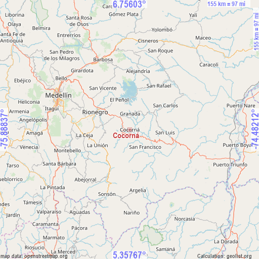
Cocorná GPS coordinates[2]
6° 3' 26.28" North, 75° 11' 6.864" West
| Map corner | latitude | longitude |
|---|---|---|
| Upper-left | 6.75603°, | -75.88837° |
| Center: | 6.0573°, | -75.18524° |
| Lower-right: | 5.35767°, | -74.48212° |
| Map W x H: | 155.5×155.5 km | = 96.6×96.6mi |
| max Lat: | 13.38166° ⇑39.6% North |
| Cocorná: | 6.0573° |
| min Lat: | ⇓60.4% South -4.21528° |
| min Long | Cocorná | max Long |
| -81.70636° | -75.18524° | -67.06996° |
| W 41.1%⇐ | ⇒58.9% E |
Elevation
Elevation of Cocorná is 1304 m = 4278 ft, and this is 154.7 m = 508 ft above average elevation for this country.
| Max E: |
3342 m = 10965 ft | 44.7% |
| Cocorná | 1304 m 4278 ft | |
| Avg. | 1149.3 m = 3771 ft | |
Min E: |
1 m = 3 ft | 55.3% |
See also: Colombia elevation on elevation.city.
Geographical zone
Cocorná is located in North Torrid zone (between Equator and Tropic of Cancer). Distance of Equator is 673.5 km =418.5 mi to South.| Distance of | km | miles | from Cocorná |
|---|---|---|---|
| North Pole | 9333.6 | 5799.6 | to North |
| Arctic Circle | 6727.7 | 4180.4 | to North |
| Tropic Cancer | 1932.4 | 1200.7 | to North |
| Equator | 673.5 | 418.5 | to South |


Nearby cities:
15 places around Cocorná: (largest is in red/bold)
• Carmen de Viboral
16.8 km =10.4 mi,  279°
279°
• El Carmen
19 km =11.8 mi,  172°
172°
• Granada
9.6 km =6 mi,  359°
359°
• Guatapé
19.8 km =12.3 mi,  7°
7°
• La Ceja
27.6 km =17.1 mi,  263°
263°
• La Unión
21.6 km =13.4 mi,  244°
244°
• Marinilla
21.1 km =13.1 mi,  307°
307°
• Retiro
35.1 km =21.8 mi,  270°
270°
• Rionegro
23.5 km =14.6 mi,  297°
297°
• San Carlos
25.7 km =16 mi,  55°
55°
• San Francisco
13.9 km =8.6 mi,  138°
138°
• San Luis
21.2 km =13.2 mi,  94°
94°
• San Rafael
31.7 km =19.7 mi,  33°
33°
• San Vicente
30.2 km =18.8 mi,  327°
327°
• Santuario
12.5 km =7.8 mi,  315°
315°
Sources, notices
• [Note1] Compared only with cities in Colombia existing in our database
• [Src1] Map data: © OpenStreetMap contributors (CC-BY-SA)
• [Src2] Other city data from geonames.org with taken over terms of usage.
• [Src3] Geographical zone / Annual Mean Temperature by Robert A. Rohde @ Wikipedia
