Chita geodata
Chita (Boyacá) is a seat of a second-order administrative division; located in Colombia in America/Bogota (GMT-5) time zone. With population of 2,914 people, there are 690 cities with bigger population in this country. Compared to other cities in Colombia, 63.1% of cities are located further ↓South; 96% of cities are located further ←West and 98.5% of cities have lower elevation than Chita. Note1


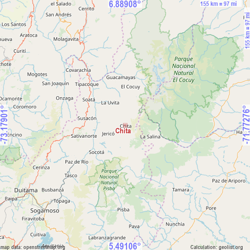
Chita GPS coordinates[2]
6° 11' 25.908" North, 72° 28' 33.168" West
| Map corner | latitude | longitude |
|---|---|---|
| Upper-left | 6.88908°, | -73.17901° |
| Center: | 6.19053°, | -72.47588° |
| Lower-right: | 5.49106°, | -71.77276° |
| Map W x H: | 155.4×155.4 km | = 96.6×96.6mi |
| max Lat: | 13.38166° ⇑36.9% North |
| Chita: | 6.19053° |
| min Lat: | ⇓63.1% South -4.21528° |
| min Long | Chita | max Long |
| -81.70636° | -72.47588° | -67.06996° |
| W 96%⇐ | ⇒4% E |
Elevation
Elevation of Chita is 2934 m = 9626 ft, and this is 1784.7 m = 5855 ft above average elevation for this country.
| Max E: |
3342 m = 10965 ft | 1.5% |
| Chita | 2934 m 9626 ft | |
| Avg. | 1149.3 m = 3771 ft | |
Min E: |
1 m = 3 ft | 98.5% |
See also: Colombia elevation on elevation.city.
Geographical zone
Chita is located in North Torrid zone (between Equator and Tropic of Cancer). Distance of Equator is 688.3 km =427.7 mi to South.| Distance of | km | miles | from Chita |
|---|---|---|---|
| North Pole | 9318.7 | 5790.4 | to North |
| Arctic Circle | 6712.9 | 4171.2 | to North |
| Tropic Cancer | 1917.6 | 1191.5 | to North |
| Equator | 688.3 | 427.7 | to South |


Nearby cities:
15 places around Chita: (largest is in red/bold)
• Boavita
19.7 km =12.2 mi,  322°
322°
• El Cocuy
24.8 km =15.4 mi,  6°
6°
• Guacamayas
30.4 km =18.9 mi,  353°
353°
• Güicán
31.3 km =19.4 mi, 12°
• Jericó
11.6 km =7.2 mi,  244°
244°
• La Salina
16.5 km =10.3 mi,  113°
113°
• La Uvita
17.4 km =10.8 mi,  326°
326°
• Panqueba
28.4 km =17.6 mi,  2°
2°
• San Mateo
25 km =15.5 mi,  340°
340°
• Sativanorte
26.6 km =16.5 mi,  255°
255°
• Sativasur
29.7 km =18.5 mi,  247°
247°
• Soatá
27.9 km =17.3 mi,  304°
304°
• Socotá
24.3 km =15.1 mi,  226°
226°
• Susacón
24.1 km =15 mi,  280°
280°
• Sácama
27.1 km =16.8 mi, 112°
Sources, notices
• [Note1] Compared only with cities in Colombia existing in our database
• [Src1] Map data: © OpenStreetMap contributors (CC-BY-SA)
• [Src2] Other city data from geonames.org with taken over terms of usage.
• [Src3] Geographical zone / Annual Mean Temperature by Robert A. Rohde @ Wikipedia
