Ebéjico geodata
Ebéjico (Antioquia) is a seat of a second-order administrative division; located in Colombia in America/Bogota (GMT-5) time zone. With population of 2,583 people, there are 731 cities with bigger population in this country. Compared to other cities in Colombia, 65.2% of cities are located further ↓South; 74.3% of cities are located further →East and 51% of cities have lower elevation than Ebéjico. Note1


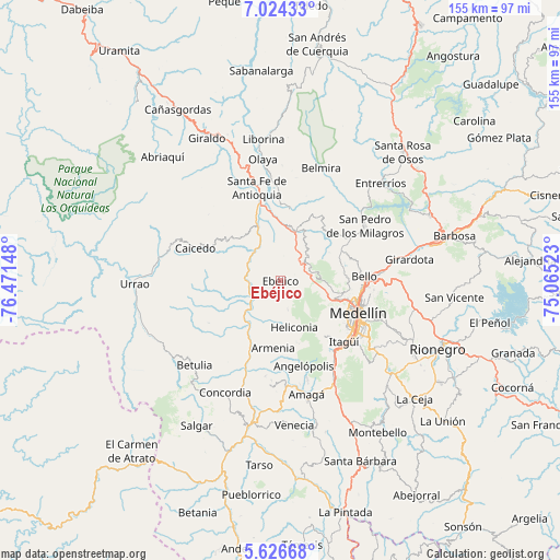
Ebéjico GPS coordinates[2]
6° 19' 33.528" North, 75° 46' 6.06" West
| Map corner | latitude | longitude |
|---|---|---|
| Upper-left | 7.02433°, | -76.47148° |
| Center: | 6.32598°, | -75.76835° |
| Lower-right: | 5.62668°, | -75.06523° |
| Map W x H: | 155.4×155.4 km | = 96.6×96.6mi |
| max Lat: | 13.38166° ⇑34.8% North |
| Ebéjico: | 6.32598° |
| min Lat: | ⇓65.2% South -4.21528° |
| min Long | Ebéjico | max Long |
| -81.70636° | -75.76835° | -67.06996° |
| W 25.7%⇐ | ⇒74.3% E |
Elevation
Elevation of Ebéjico is 1159 m = 3802 ft, and this is 9.7 m = 32 ft above average elevation for this country.
| Max E: |
3342 m = 10965 ft | 49% |
| Ebéjico | 1159 m 3802 ft | |
| Avg. | 1149.3 m = 3771 ft | |
Min E: |
1 m = 3 ft | 51% |
See also: Colombia elevation on elevation.city.
Geographical zone
Ebéjico is located in North Torrid zone (between Equator and Tropic of Cancer). Distance of Equator is 703.4 km =437.1 mi to South.| Distance of | km | miles | from Ebéjico |
|---|---|---|---|
| North Pole | 9303.7 | 5781 | to North |
| Arctic Circle | 6697.8 | 4161.8 | to North |
| Tropic Cancer | 1902.5 | 1182.2 | to North |
| Equator | 703.4 | 437.1 | to South |


Nearby cities:
15 places around Ebéjico: (largest is in red/bold)
• Angelópolis
24.8 km =15.4 mi,  164°
164°
• Anzá
9.8 km =6.1 mi,  255°
255°
• Armenia
19 km =11.8 mi,  186°
186°
• Bello
23.3 km =14.5 mi,  86°
86°
• Caicedo
25.3 km =15.7 mi,  290°
290°
• Envigado
25.7 km =16 mi,  130°
130°
• Heliconia
13.6 km =8.5 mi, 164°
• Itagüí
24.4 km =15.2 mi, 130°
• La Estrella
23.3 km =14.5 mi,  143°
143°
• Medellín
24.1 km =15 mi,  110°
110°
• Sabaneta
25.6 km =15.9 mi, 139°
• San Jerónimo
13.8 km =8.6 mi,  18°
18°
• San Pedro
27.7 km =17.2 mi,  57°
57°
• Santa Fe de Antioquia
26.5 km =16.5 mi,  345°
345°
• Sopetrán
19.7 km =12.2 mi,  8°
8°
Sources, notices
• [Note1] Compared only with cities in Colombia existing in our database
• [Src1] Map data: © OpenStreetMap contributors (CC-BY-SA)
• [Src2] Other city data from geonames.org with taken over terms of usage.
• [Src3] Geographical zone / Annual Mean Temperature by Robert A. Rohde @ Wikipedia
