Santa Fe de Antioquia geodata
Santa Fe de Antioquia (Antioquia) is a seat of a second-order administrative division; located in Colombia in America/Bogota (GMT-5) time zone. With population of 11,829 people, there are 256 cities with bigger population in this country. Compared to other cities in Colombia, 69.4% of cities are located further ↓South; 76.8% of cities are located further →East and 62.8% of cities have higher elevation than Santa Fe de Antioquia. Note1


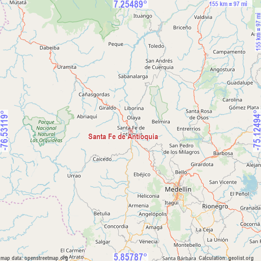
Santa Fe de Antioquia GPS coordinates[2]
6° 33' 24.732" North, 75° 49' 41.016" West
| Map corner | latitude | longitude |
|---|---|---|
| Upper-left | 7.25489°, | -76.53119° |
| Center: | 6.55687°, | -75.82806° |
| Lower-right: | 5.85787°, | -75.12494° |
| Map W x H: | 155.3×155.3 km | = 96.5×96.5mi |
| max Lat: | 13.38166° ⇑30.6% North |
| Santa Fe de Antioquia: | 6.55687° |
| min Lat: | ⇓69.4% South -4.21528° |
| min Long | Santa Fe de Ant | max Long |
| -81.70636° | -75.82806° | -67.06996° |
| W 23.2%⇐ | ⇒76.8% E |
Elevation
Elevation of Santa Fe de Antioquia is 571 m = 1873 ft, and this is 578.3 m = 1897 ft below average elevation for this country.
| Max E: |
3342 m = 10965 ft | 62.8% |
| Avg. | 1149.3 m = 3771 ft | |
| Santa Fe de Antioquia | 571 m = 1873 ft | |
Min E: |
1 m = 3 ft | 37.2% |
See also: Colombia elevation on elevation.city.
Geographical zone
Santa Fe de Antioquia is located in North Torrid zone (between Equator and Tropic of Cancer). Distance of Equator is 729.1 km =453 mi to South.| Distance of | km | miles | from Santa Fe de Antioquia |
|---|---|---|---|
| North Pole | 9278 | 5765.1 | to North |
| Arctic Circle | 6672.1 | 4145.8 | to North |
| Tropic Cancer | 1876.9 | 1166.3 | to North |
| Equator | 729.1 | 453 | to South |


Nearby cities:
15 places around Santa Fe de Antioquia: (largest is in red/bold)
• Abriaquí
27.4 km =17 mi,  287°
287°
• Anzá
28.3 km =17.6 mi,  185°
185°
• Belmira
18.7 km =11.6 mi,  73°
73°
• Buriticá
20 km =12.4 mi,  334°
334°
• Caicedo
24 km =14.9 mi,  225°
225°
• Cañasgordas
30.6 km =19 mi,  314°
314°
• Ebéjico
26.5 km =16.5 mi,  165°
165°
• Entrerríos
34.4 km =21.4 mi,  88°
88°
• Giraldo
19.4 km =12.1 mi, 314°
• Liborina
13.6 km =8.5 mi,  7°
7°
• Olaya
8.1 km =5 mi, 12°
• Sabanalarga
32.5 km =20.2 mi,  2°
2°
• San Jerónimo
16.8 km =10.4 mi,  138°
138°
• San Pedro
31.7 km =19.7 mi,  109°
109°
• Sopetrán
11.2 km =7 mi,  123°
123°
Sources, notices
• [Note1] Compared only with cities in Colombia existing in our database
• [Src1] Map data: © OpenStreetMap contributors (CC-BY-SA)
• [Src2] Other city data from geonames.org with taken over terms of usage.
• [Src3] Geographical zone / Annual Mean Temperature by Robert A. Rohde @ Wikipedia
