Donmatías geodata
Donmatías (Antioquia) is a seat of a second-order administrative division; located in Colombia in America/Bogota (GMT-5) time zone. With population of 10,011 people, there are 304 cities with bigger population in this country. Compared to other cities in Colombia, 68.2% of cities are located further ↓South; 63.7% of cities are located further →East and 82.9% of cities have lower elevation than Donmatías. Note1


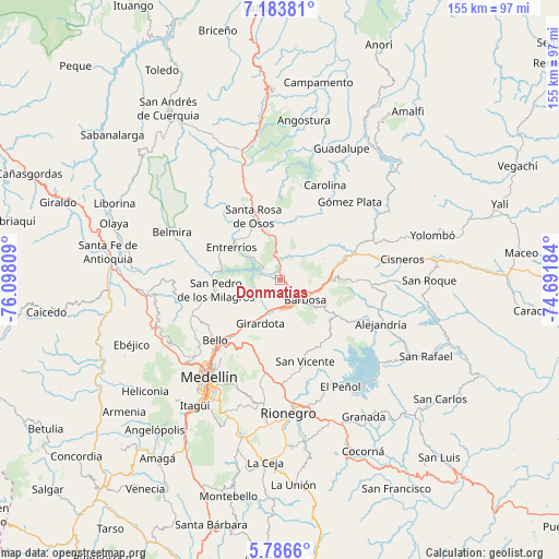
Donmatías GPS coordinates[2]
6° 29' 8.484" North, 75° 23' 41.856" West
| Map corner | latitude | longitude |
|---|---|---|
| Upper-left | 7.18381°, | -76.09809° |
| Center: | 6.48569°, | -75.39496° |
| Lower-right: | 5.7866°, | -74.69184° |
| Map W x H: | 155.4×155.4 km | = 96.6×96.6mi |
| max Lat: | 13.38166° ⇑31.8% North |
| Donmatías: | 6.48569° |
| min Lat: | ⇓68.2% South -4.21528° |
| min Long | Donmatías | max Long |
| -81.70636° | -75.39496° | -67.06996° |
| W 36.3%⇐ | ⇒63.7% E |
Elevation
Elevation of Donmatías is 2157 m = 7077 ft, and this is 1007.7 m = 3306 ft above average elevation for this country.
| Max E: |
3342 m = 10965 ft | 17.1% |
| Donmatías | 2157 m 7077 ft | |
| Avg. | 1149.3 m = 3771 ft | |
Min E: |
1 m = 3 ft | 82.9% |
See also: Colombia elevation on elevation.city.
Geographical zone
Donmatías is located in North Torrid zone (between Equator and Tropic of Cancer). Distance of Equator is 721.1 km =448.1 mi to South.| Distance of | km | miles | from Donmatías |
|---|---|---|---|
| North Pole | 9285.9 | 5770 | to North |
| Arctic Circle | 6680 | 4150.8 | to North |
| Tropic Cancer | 1884.8 | 1171.2 | to North |
| Equator | 721.1 | 448.1 | to South |


Nearby cities:
15 places around Donmatías: (largest is in red/bold)
• Alejandría
30.6 km =19 mi,  113°
113°
• Barbosa
8.8 km =5.5 mi,  126°
126°
• Bello
24.4 km =15.2 mi,  227°
227°
• Carolina
29.3 km =18.2 mi,  25°
25°
• Concepción
18.2 km =11.3 mi,  124°
124°
• Copacabana
20 km =12.4 mi,  219°
219°
• Entrerríos
16.1 km =10 mi,  303°
303°
• Girardota
13.4 km =8.3 mi,  206°
206°
• Guarne
23.4 km =14.5 mi,  193°
193°
• Gómez Plata
29.2 km =18.1 mi,  41°
41°
• Medellín
32 km =19.9 mi, 215°
• San Pedro
18.2 km =11.3 mi,  261°
261°
• San Vicente
23.3 km =14.5 mi,  163°
163°
• Santa Rosa de Osos
19.4 km =12.1 mi,  338°
338°
• Santo Domingo
25.4 km =15.8 mi,  93°
93°
Sources, notices
• [Note1] Compared only with cities in Colombia existing in our database
• [Src1] Map data: © OpenStreetMap contributors (CC-BY-SA)
• [Src2] Other city data from geonames.org with taken over terms of usage.
• [Src3] Geographical zone / Annual Mean Temperature by Robert A. Rohde @ Wikipedia
