Girardota geodata
Girardota (Antioquia) is a seat of a second-order administrative division; located in Colombia in America/Bogota (GMT-5) time zone. In our database, there are 1053 cities with bigger population. Compared to other cities in Colombia, 66.1% of cities are located further ↓South; 65.4% of cities are located further →East and 58.7% of cities have lower elevation than Girardota. Note1


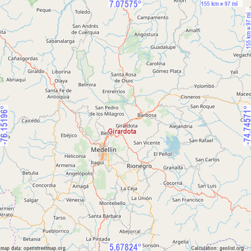
Girardota GPS coordinates[2]
6° 22' 38.892" North, 75° 26' 55.788" West
| Map corner | latitude | longitude |
|---|---|---|
| Upper-left | 7.07575°, | -76.15196° |
| Center: | 6.37747°, | -75.44883° |
| Lower-right: | 5.67824°, | -74.74571° |
| Map W x H: | 155.4×155.4 km | = 96.6×96.6mi |
| max Lat: | 13.38166° ⇑33.9% North |
| Girardota: | 6.37747° |
| min Lat: | ⇓66.1% South -4.21528° |
| min Long | Girardota | max Long |
| -81.70636° | -75.44883° | -67.06996° |
| W 34.6%⇐ | ⇒65.4% E |
Elevation
Elevation of Girardota is 1427 m = 4682 ft, and this is 277.7 m = 911 ft above average elevation for this country.
| Max E: |
3342 m = 10965 ft | 41.3% |
| Girardota | 1427 m 4682 ft | |
| Avg. | 1149.3 m = 3771 ft | |
Min E: |
1 m = 3 ft | 58.7% |
See also: Colombia elevation on elevation.city.
Geographical zone
Girardota is located in North Torrid zone (between Equator and Tropic of Cancer). Distance of Equator is 709.1 km =440.6 mi to South.| Distance of | km | miles | from Girardota |
|---|---|---|---|
| North Pole | 9298 | 5777.5 | to North |
| Arctic Circle | 6692.1 | 4158.3 | to North |
| Tropic Cancer | 1896.8 | 1178.6 | to North |
| Equator | 709.1 | 440.6 | to South |


Nearby cities:
15 places around Girardota: (largest is in red/bold)
• Barbosa
14.6 km =9.1 mi,  62°
62°
• Bello
12.9 km =8 mi,  249°
249°
• Concepción
21.1 km =13.1 mi,  84°
84°
• Copacabana
7.5 km =4.7 mi,  242°
242°
• Donmatías
13.4 km =8.3 mi,  26°
26°
• Entrerríos
22.2 km =13.8 mi,  340°
340°
• Envigado
27.4 km =17 mi,  215°
215°
• Guarne
10.8 km =6.7 mi,  176°
176°
• Itagüí
27.1 km =16.8 mi, 217°
• Marinilla
25.9 km =16.1 mi,  151°
151°
• Medellín
18.9 km =11.7 mi, 222°
• Rionegro
26.1 km =16.2 mi,  161°
161°
• San Pedro
15.2 km =9.4 mi,  307°
307°
• San Vicente
16.3 km =10.1 mi,  128°
128°
• Santa Rosa de Osos
30 km =18.6 mi,  357°
357°
Sources, notices
• [Note1] Compared only with cities in Colombia existing in our database
• [Src1] Map data: © OpenStreetMap contributors (CC-BY-SA)
• [Src2] Other city data from geonames.org with taken over terms of usage.
• [Src3] Geographical zone / Annual Mean Temperature by Robert A. Rohde @ Wikipedia
