Santa Rosa de Osos geodata
Santa Rosa de Osos (Antioquia) is a seat of a second-order administrative division; located in Colombia in America/Bogota (GMT-5) time zone. With population of 10,191 people, there are 300 cities with bigger population in this country. Compared to other cities in Colombia, 70.6% of cities are located further ↓South; 65.7% of cities are located further →East and 92.5% of cities have lower elevation than Santa Rosa de Osos. Note1


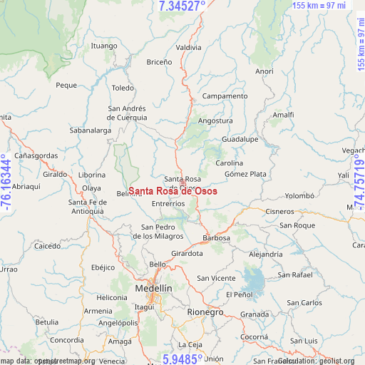
Santa Rosa de Osos GPS coordinates[2]
6° 38' 50.568" North, 75° 27' 37.116" West
| Map corner | latitude | longitude |
|---|---|---|
| Upper-left | 7.34527°, | -76.16344° |
| Center: | 6.64738°, | -75.46031° |
| Lower-right: | 5.9485°, | -74.75719° |
| Map W x H: | 155.3×155.3 km | = 96.5×96.5mi |
| max Lat: | 13.38166° ⇑29.4% North |
| Santa Rosa de Osos: | 6.64738° |
| min Lat: | ⇓70.6% South -4.21528° |
| min Long | Santa Rosa de O | max Long |
| -81.70636° | -75.46031° | -67.06996° |
| W 34.3%⇐ | ⇒65.7% E |
Elevation
Elevation of Santa Rosa de Osos is 2586 m = 8484 ft, and this is 1436.7 m = 4714 ft above average elevation for this country.
| Max E: |
3342 m = 10965 ft | 7.5% |
| Santa Rosa de Osos | 2586 m 8484 ft | |
| Avg. | 1149.3 m = 3771 ft | |
Min E: |
1 m = 3 ft | 92.5% |
See also: Colombia elevation on elevation.city.
Geographical zone
Santa Rosa de Osos is located in North Torrid zone (between Equator and Tropic of Cancer). Distance of Equator is 739.1 km =459.3 mi to South.| Distance of | km | miles | from Santa Rosa de Osos |
|---|---|---|---|
| North Pole | 9267.9 | 5758.8 | to North |
| Arctic Circle | 6662.1 | 4139.6 | to North |
| Tropic Cancer | 1866.8 | 1160 | to North |
| Equator | 739.1 | 459.3 | to South |


Nearby cities:
15 places around Santa Rosa de Osos: (largest is in red/bold)
• Angostura
29.8 km =18.5 mi,  27°
27°
• Barbosa
27.3 km =17 mi,  148°
148°
• Belmira
23.2 km =14.4 mi,  258°
258°
• Carolina
21.5 km =13.4 mi,  66°
66°
• Concepción
35.9 km =22.3 mi,  141°
141°
• Copacabana
33.9 km =21.1 mi,  189°
189°
• Donmatías
19.4 km =12.1 mi,  158°
158°
• Entrerríos
11.1 km =6.9 mi,  214°
214°
• Girardota
30 km =18.6 mi,  177°
177°
• Guadalupe
30.6 km =19 mi,  52°
52°
• Gómez Plata
26.9 km =16.7 mi,  81°
81°
• San José de la Montaña
33.4 km =20.8 mi,  312°
312°
• San Pedro
23.3 km =14.5 mi, 207°
• Sopetrán
35.2 km =21.9 mi,  242°
242°
• Yarumal
35.4 km =22 mi,  7°
7°
Sources, notices
• [Note1] Compared only with cities in Colombia existing in our database
• [Src1] Map data: © OpenStreetMap contributors (CC-BY-SA)
• [Src2] Other city data from geonames.org with taken over terms of usage.
• [Src3] Geographical zone / Annual Mean Temperature by Robert A. Rohde @ Wikipedia
