Copacabana geodata
Copacabana (Antioquia) is a seat of a second-order administrative division; located in Colombia in America/Bogota (GMT-5) time zone. With population of 49,169 people, there are 84 cities with bigger population in this country. Compared to other cities in Colombia, 65.9% of cities are located further ↓South; 66.6% of cities are located further →East and 58.1% of cities have lower elevation than Copacabana. Note1


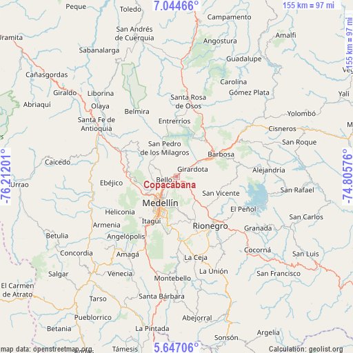
Copacabana GPS coordinates[2]
6° 20' 46.788" North, 75° 30' 31.968" West
| Map corner | latitude | longitude |
|---|---|---|
| Upper-left | 7.04466°, | -76.21201° |
| Center: | 6.34633°, | -75.50888° |
| Lower-right: | 5.64706°, | -74.80576° |
| Map W x H: | 155.4×155.4 km | = 96.6×96.6mi |
| max Lat: | 13.38166° ⇑34.1% North |
| Copacabana: | 6.34633° |
| min Lat: | ⇓65.9% South -4.21528° |
| min Long | Copacabana | max Long |
| -81.70636° | -75.50888° | -67.06996° |
| W 33.4%⇐ | ⇒66.6% E |
Elevation
Elevation of Copacabana is 1411 m = 4629 ft, and this is 261.7 m = 859 ft above average elevation for this country.
| Max E: |
3342 m = 10965 ft | 41.9% |
| Copacabana | 1411 m 4629 ft | |
| Avg. | 1149.3 m = 3771 ft | |
Min E: |
1 m = 3 ft | 58.1% |
See also: Copacabana elevation on elevation.city.
Geographical zone
Copacabana is located in North Torrid zone (between Equator and Tropic of Cancer). Distance of Equator is 705.6 km =438.4 mi to South.| Distance of | km | miles | from Copacabana |
|---|---|---|---|
| North Pole | 9301.4 | 5779.6 | to North |
| Arctic Circle | 6695.5 | 4160.4 | to North |
| Tropic Cancer | 1900.3 | 1180.8 | to North |
| Equator | 705.6 | 438.4 | to South |


Nearby cities:
15 places around Copacabana: (largest is in red/bold)
• Barbosa
22.1 km =13.7 mi,  62°
62°
• Bello
5.5 km =3.4 mi,  259°
259°
• Donmatías
20 km =12.4 mi,  39°
39°
• Entrerríos
24.4 km =15.2 mi,  357°
357°
• Envigado
21 km =13 mi,  205°
205°
• Girardota
7.5 km =4.7 mi, 62°
• Guarne
10.3 km =6.4 mi,  135°
135°
• Itagüí
20.6 km =12.8 mi, 209°
• La Estrella
25.7 km =16 mi,  215°
215°
• Medellín
12.1 km =7.5 mi, 209°
• Rionegro
26 km =16.2 mi, 144°
• Sabaneta
24.7 km =15.3 mi, 208°
• San Jerónimo
26.5 km =16.5 mi,  294°
294°
• San Pedro
13.9 km =8.6 mi,  337°
337°
• San Vicente
20.5 km =12.7 mi,  109°
109°
Sources, notices
• [Note1] Compared only with cities in Colombia existing in our database
• [Src1] Map data: © OpenStreetMap contributors (CC-BY-SA)
• [Src2] Other city data from geonames.org with taken over terms of usage.
• [Src3] Geographical zone / Annual Mean Temperature by Robert A. Rohde @ Wikipedia
