Oicatá geodata
Oicatá (Boyacá) is a seat of a second-order administrative division; located in Colombia in America/Bogota (GMT-5) time zone. With population of 327 people, there are 1042 cities with bigger population in this country. Compared to other cities in Colombia, 51.8% of cities are located further ↓South; 80.3% of cities are located further ←West and 96% of cities have lower elevation than Oicatá. Note1


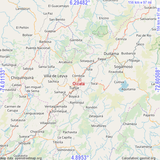
Oicatá GPS coordinates[2]
5° 35' 43.728" North, 73° 18' 29.52" West
| Map corner | latitude | longitude |
|---|---|---|
| Upper-left | 6.29482°, | -74.01133° |
| Center: | 5.59548°, | -73.3082° |
| Lower-right: | 4.8953°, | -72.60508° |
| Map W x H: | 155.6×155.6 km | = 96.7×96.7mi |
| max Lat: | 13.38166° ⇑48.2% North |
| Oicatá: | 5.59548° |
| min Lat: | ⇓51.8% South -4.21528° |
| min Long | Oicatá | max Long |
| -81.70636° | -73.3082° | -67.06996° |
| W 80.3%⇐ | ⇒19.7% E |
Elevation
Elevation of Oicatá is 2715 m = 8907 ft, and this is 1565.7 m = 5137 ft above average elevation for this country.
| Max E: |
3342 m = 10965 ft | 4% |
| Oicatá | 2715 m 8907 ft | |
| Avg. | 1149.3 m = 3771 ft | |
Min E: |
1 m = 3 ft | 96% |
See also: Colombia elevation on elevation.city.
Geographical zone
Oicatá is located in North Torrid zone (between Equator and Tropic of Cancer). Distance of Equator is 622.2 km =386.6 mi to South.| Distance of | km | miles | from Oicatá |
|---|---|---|---|
| North Pole | 9384.9 | 5831.5 | to North |
| Arctic Circle | 6779 | 4212.3 | to North |
| Tropic Cancer | 1983.8 | 1232.7 | to North |
| Equator | 622.2 | 386.6 | to South |


Nearby cities:
15 places around Oicatá: (largest is in red/bold)
• Boyacá
16.9 km =10.5 mi,  200°
200°
• Chivatá
5.1 km =3.2 mi,  144°
144°
• Chíquiza
19.6 km =12.2 mi,  272°
272°
• Combita
4.3 km =2.7 mi,  347°
347°
• Cucaita
17.2 km =10.7 mi,  250°
250°
• Cómbita
4.5 km =2.8 mi,  337°
337°
• Motavita
6.8 km =4.2 mi, 252°
• Siachoque
11.6 km =7.2 mi, 142°
• Sora
16.1 km =10 mi,  257°
257°
• Soracá
10.9 km =6.8 mi,  194°
194°
• Sotaquirá
20 km =12.4 mi,  19°
19°
• Toca
14.2 km =8.8 mi,  104°
104°
• Tunja
9.4 km =5.8 mi,  224°
224°
• Tuta
13.7 km =8.5 mi,  40°
40°
• Viracachá
17.7 km =11 mi,  175°
175°
Sources, notices
• [Note1] Compared only with cities in Colombia existing in our database
• [Src1] Map data: © OpenStreetMap contributors (CC-BY-SA)
• [Src2] Other city data from geonames.org with taken over terms of usage.
• [Src3] Geographical zone / Annual Mean Temperature by Robert A. Rohde @ Wikipedia
