Sora geodata
Sora (Boyacá) is a seat of a second-order administrative division; located in Colombia in America/Bogota (GMT-5) time zone. With population of 508 people, there are 1027 cities with bigger population in this country. Compared to other cities in Colombia, 51.3% of cities are located further ↓South; 76.8% of cities are located further ←West and 94.8% of cities have lower elevation than Sora. Note1


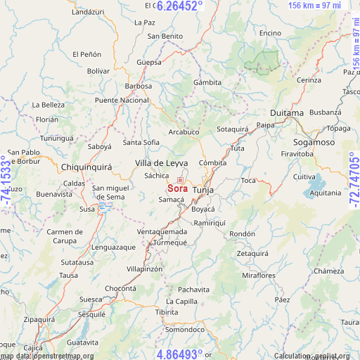
Sora GPS coordinates[2]
5° 33' 54.504" North, 73° 27' 0.612" West
| Map corner | latitude | longitude |
|---|---|---|
| Upper-left | 6.26452°, | -74.1533° |
| Center: | 5.56514°, | -73.45017° |
| Lower-right: | 4.86493°, | -72.74705° |
| Map W x H: | 155.6×155.6 km | = 96.7×96.7mi |
| max Lat: | 13.38166° ⇑48.7% North |
| Sora: | 5.56514° |
| min Lat: | ⇓51.3% South -4.21528° |
| min Long | Sora | max Long |
| -81.70636° | -73.45017° | -67.06996° |
| W 76.8%⇐ | ⇒23.2% E |
Elevation
Elevation of Sora is 2668 m = 8753 ft, and this is 1518.7 m = 4983 ft above average elevation for this country.
| Max E: |
3342 m = 10965 ft | 5.2% |
| Sora | 2668 m 8753 ft | |
| Avg. | 1149.3 m = 3771 ft | |
Min E: |
1 m = 3 ft | 94.8% |
See also: Colombia elevation on elevation.city.
Geographical zone
Sora is located in North Torrid zone (between Equator and Tropic of Cancer). Distance of Equator is 618.8 km =384.5 mi to South.| Distance of | km | miles | from Sora |
|---|---|---|---|
| North Pole | 9388.3 | 5833.6 | to North |
| Arctic Circle | 6782.4 | 4214.4 | to North |
| Tropic Cancer | 1987.1 | 1234.7 | to North |
| Equator | 618.8 | 384.5 | to South |


Nearby cities:
15 places around Sora: (largest is in red/bold)
• Boyacá
15.7 km =9.8 mi,  141°
141°
• Chivatá
18.6 km =11.6 mi,  92°
92°
• Chíquiza
5.8 km =3.6 mi,  318°
318°
• Combita
16.6 km =10.3 mi,  62°
62°
• Cucaita
2.4 km =1.5 mi,  190°
190°
• Cómbita
15.9 km =9.9 mi, 61°
• La Capilla
15.8 km =9.8 mi,  349°
349°
• Motavita
9.3 km =5.8 mi,  82°
82°
• Oicatá
16.1 km =10 mi, 77°
• Samacá
8.9 km =5.5 mi,  205°
205°
• Soracá
14.8 km =9.2 mi,  118°
118°
• Sutamarchán
19.3 km =12 mi,  286°
286°
• Sáchica
10.4 km =6.5 mi,  281°
281°
• Tunja
9.7 km =6 mi,  110°
110°
• Villa de Leyva
11.2 km =7 mi,  313°
313°
Sources, notices
• [Note1] Compared only with cities in Colombia existing in our database
• [Src1] Map data: © OpenStreetMap contributors (CC-BY-SA)
• [Src2] Other city data from geonames.org with taken over terms of usage.
• [Src3] Geographical zone / Annual Mean Temperature by Robert A. Rohde @ Wikipedia
