Astrea geodata
Astrea (Cesar) is a seat of a second-order administrative division; located in Colombia in America/Bogota (GMT-5) time zone. With population of 8,995 people, there are 341 cities with bigger population in this country. Compared to other cities in Colombia, 91% of cities are located further ↓South; 65.4% of cities are located further ←West and 82.5% of cities have higher elevation than Astrea. Note1


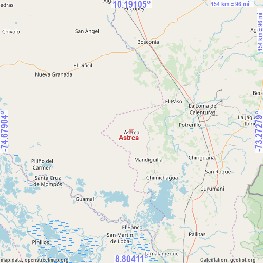
Astrea GPS coordinates[2]
9° 29' 53.808" North, 73° 58' 33.276" West
| Map corner | latitude | longitude |
|---|---|---|
| Upper-left | 10.19105°, | -74.67904° |
| Center: | 9.49828°, | -73.97591° |
| Lower-right: | 8.80411°, | -73.27279° |
| Map W x H: | 154.2×154.2 km | = 95.8×95.8mi |
| max Lat: | 13.38166° ⇑9% North |
| Astrea: | 9.49828° |
| min Lat: | ⇓91% South -4.21528° |
| min Long | Astrea | max Long |
| -81.70636° | -73.97591° | -67.06996° |
| W 65.4%⇐ | ⇒34.6% E |
Elevation
Elevation of Astrea is 87 m = 285 ft, and this is 1062.3 m = 3485 ft below average elevation for this country.
| Max E: |
3342 m = 10965 ft | 82.5% |
| Avg. | 1149.3 m = 3771 ft | |
| Astrea | 87 m = 285 ft | |
Min E: |
1 m = 3 ft | 17.5% |
See also: Colombia elevation on elevation.city.
Geographical zone
Astrea is located in North Torrid zone (between Equator and Tropic of Cancer). Distance of Equator is 1056.1 km =656.2 mi to South.| Distance of | km | miles | from Astrea |
|---|---|---|---|
| North Pole | 8951 | 5561.9 | to North |
| Arctic Circle | 6345.1 | 3942.7 | to North |
| Tropic Cancer | 1549.8 | 963 | to North |
| Equator | 1056.1 | 656.2 | to South |


Nearby cities:
15 places around Astrea: (largest is in red/bold)
• Bosconia
53.4 km =33.2 mi,  10°
10°
• Buenavista
48.7 km =30.3 mi,  229°
229°
• Chimichagua
32.2 km =20 mi,  146°
146°
• Chiriguaná
43.6 km =27.1 mi,  110°
110°
• El Banco
55.3 km =34.4 mi,  179°
179°
• El Difícil
48.4 km =30.1 mi,  323°
323°
• El Paso
30.7 km =19.1 mi,  54°
54°
• El Peñón
56.9 km =35.4 mi, 176°
• Guamal
47.9 km =29.8 mi,  214°
214°
• Margarita
49.6 km =30.8 mi,  219°
219°
• Mompós
57.1 km =35.5 mi,  240°
240°
• Nueva Granada
56.8 km =35.3 mi,  306°
306°
• Pijiño del Carmen
55.6 km =34.5 mi,  250°
250°
• San Fernando
49.3 km =30.6 mi, 229°
• San Sebastián de Buenavista
50.4 km =31.3 mi, 234°
Sources, notices
• [Note1] Compared only with cities in Colombia existing in our database
• [Src1] Map data: © OpenStreetMap contributors (CC-BY-SA)
• [Src2] Other city data from geonames.org with taken over terms of usage.
• [Src3] Geographical zone / Annual Mean Temperature by Robert A. Rohde @ Wikipedia
