Chiriguaná geodata
Chiriguaná (Cesar) is a seat of a second-order administrative division; located in Colombia in America/Bogota (GMT-5) time zone. With population of 15,181 people, there are 221 cities with bigger population in this country. Compared to other cities in Colombia, 90.3% of cities are located further ↓South; 73.6% of cities are located further ←West and 89.1% of cities have higher elevation than Chiriguaná. Note1


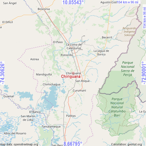
Chiriguaná GPS coordinates[2]
9° 21' 44.568" North, 73° 36' 11.268" West
| Map corner | latitude | longitude |
|---|---|---|
| Upper-left | 10.05543°, | -74.30626° |
| Center: | 9.36238°, | -73.60313° |
| Lower-right: | 8.66795°, | -72.90001° |
| Map W x H: | 154.3×154.3 km | = 95.9×95.9mi |
| max Lat: | 13.38166° ⇑9.7% North |
| Chiriguaná: | 9.36238° |
| min Lat: | ⇓90.3% South -4.21528° |
| min Long | Chiriguaná | max Long |
| -81.70636° | -73.60313° | -67.06996° |
| W 73.6%⇐ | ⇒26.4% E |
Elevation
Elevation of Chiriguaná is 33 m = 108 ft, and this is 1116.3 m = 3662 ft below average elevation for this country.
| Max E: |
3342 m = 10965 ft | 89.1% |
| Avg. | 1149.3 m = 3771 ft | |
| Chiriguaná | 33 m = 108 ft | |
Min E: |
1 m = 3 ft | 10.9% |
See also: Colombia elevation on elevation.city.
Geographical zone
Chiriguaná is located in North Torrid zone (between Equator and Tropic of Cancer). Distance of Equator is 1041 km =646.8 mi to South.| Distance of | km | miles | from Chiriguaná |
|---|---|---|---|
| North Pole | 8966.1 | 5571.3 | to North |
| Arctic Circle | 6360.2 | 3952 | to North |
| Tropic Cancer | 1564.9 | 972.4 | to North |
| Equator | 1041 | 646.8 | to South |


Nearby cities:
15 places around Chiriguaná: (largest is in red/bold)
• Astrea
43.6 km =27.1 mi,  290°
290°
• Barranco de Loba
72.1 km =44.8 mi,  230°
230°
• Becerril
52 km =32.3 mi,  43°
43°
• Bosconia
74.5 km =46.3 mi,  335°
335°
• Chimichagua
25.7 km =16 mi,  243°
243°
• Curumaní
19.2 km =11.9 mi,  159°
159°
• El Banco
57.3 km =35.6 mi, 225°
• El Paso
36.4 km =22.6 mi,  334°
334°
• El Peñón
56.3 km =35 mi,  222°
222°
• Guamal
72.3 km =44.9 mi,  250°
250°
• Hatillo de Loba
69 km =42.9 mi, 229°
• La Jagua de Ibirico
36.9 km =22.9 mi,  53°
53°
• Pailitas
45.2 km =28.1 mi,  183°
183°
• San Martín de Loba
67.4 km =41.9 mi, 225°
• Tamalameque
61.2 km =38 mi,  202°
202°
Sources, notices
• [Note1] Compared only with cities in Colombia existing in our database
• [Src1] Map data: © OpenStreetMap contributors (CC-BY-SA)
• [Src2] Other city data from geonames.org with taken over terms of usage.
• [Src3] Geographical zone / Annual Mean Temperature by Robert A. Rohde @ Wikipedia
