El Paso geodata
El Paso (Cesar) is a seat of a second-order administrative division; located in Colombia in America/Bogota (GMT-5) time zone. With population of 6,367 people, there are 430 cities with bigger population in this country. Compared to other cities in Colombia, 91.5% of cities are located further ↓South; 71% of cities are located further ←West and 87.6% of cities have higher elevation than El Paso. Note1


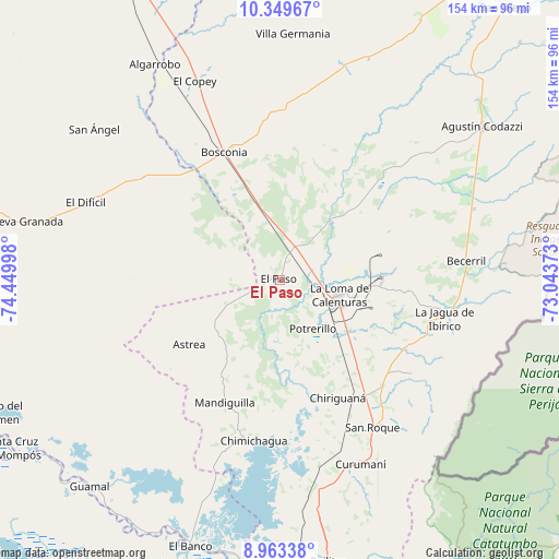
El Paso GPS coordinates[2]
9° 39' 26.064" North, 73° 44' 48.66" West
| Map corner | latitude | longitude |
|---|---|---|
| Upper-left | 10.34967°, | -74.44998° |
| Center: | 9.65724°, | -73.74685° |
| Lower-right: | 8.96338°, | -73.04373° |
| Map W x H: | 154.1×154.1 km | = 95.8×95.8mi |
| max Lat: | 13.38166° ⇑8.5% North |
| El Paso: | 9.65724° |
| min Lat: | ⇓91.5% South -4.21528° |
| min Long | El Paso | max Long |
| -81.70636° | -73.74685° | -67.06996° |
| W 71%⇐ | ⇒29% E |
Elevation
Elevation of El Paso is 41 m = 135 ft, and this is 1108.3 m = 3636 ft below average elevation for this country.
| Max E: |
3342 m = 10965 ft | 87.6% |
| Avg. | 1149.3 m = 3771 ft | |
| El Paso | 41 m = 135 ft | |
Min E: |
1 m = 3 ft | 12.4% |
See also: Colombia elevation on elevation.city.
Geographical zone
El Paso is located in North Torrid zone (between Equator and Tropic of Cancer). Distance of Equator is 1073.8 km =667.2 mi to South.| Distance of | km | miles | from El Paso |
|---|---|---|---|
| North Pole | 8933.3 | 5550.9 | to North |
| Arctic Circle | 6327.4 | 3931.7 | to North |
| Tropic Cancer | 1532.1 | 952 | to North |
| Equator | 1073.8 | 667.2 | to South |


Nearby cities:
15 places around El Paso: (largest is in red/bold)
• Agustín Codazzi
70.1 km =43.6 mi,  53°
53°
• Algarrobo
68.1 km =42.3 mi,  329°
329°
• Ariguaní
71.5 km =44.4 mi,  337°
337°
• Astrea
30.7 km =19.1 mi,  234°
234°
• Becerril
51.5 km =32 mi,  84°
84°
• Bosconia
38.2 km =23.7 mi, 336°
• Chimichagua
45 km =28 mi,  189°
189°
• Chiriguaná
36.4 km =22.6 mi,  154°
154°
• Curumaní
55.6 km =34.5 mi,  156°
156°
• El Banco
77.2 km =48 mi,  199°
199°
• El Copey
59.6 km =37 mi, 336°
• El Difícil
57.7 km =35.9 mi,  291°
291°
• La Jagua de Ibirico
46.5 km =28.9 mi,  103°
103°
• Nueva Granada
72.6 km =45.1 mi,  282°
282°
• San Ángel
66 km =41 mi,  308°
308°
Sources, notices
• [Note1] Compared only with cities in Colombia existing in our database
• [Src1] Map data: © OpenStreetMap contributors (CC-BY-SA)
• [Src2] Other city data from geonames.org with taken over terms of usage.
• [Src3] Geographical zone / Annual Mean Temperature by Robert A. Rohde @ Wikipedia
