Elías geodata
Elías (Huila) is a seat of a second-order administrative division; located in Colombia in America/Bogota (GMT-5) time zone. With population of 1,117 people, there are 929 cities with bigger population in this country. Compared to other cities in Colombia, 90% of cities are located further ↑North; 78.8% of cities are located further →East and 55% of cities have lower elevation than Elías. Note1


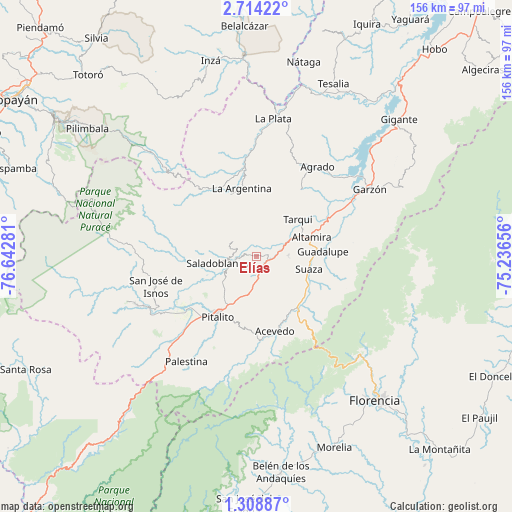
Elías GPS coordinates[2]
2° 0' 42.12" North, 75° 56' 22.848" West
| Map corner | latitude | longitude |
|---|---|---|
| Upper-left | 2.71422°, | -76.64281° |
| Center: | 2.0117°, | -75.93968° |
| Lower-right: | 1.30887°, | -75.23656° |
| Map W x H: | 156.3×156.3 km | = 97.1×97.1mi |
| max Lat: | 13.38166° ⇑90% North |
| Elías: | 2.0117° |
| min Lat: | ⇓10% South -4.21528° |
| min Long | Elías | max Long |
| -81.70636° | -75.93968° | -67.06996° |
| W 21.2%⇐ | ⇒78.8% E |
Elevation
Elevation of Elías is 1292 m = 4239 ft, and this is 142.7 m = 468 ft above average elevation for this country.
| Max E: |
3342 m = 10965 ft | 45% |
| Elías | 1292 m 4239 ft | |
| Avg. | 1149.3 m = 3771 ft | |
Min E: |
1 m = 3 ft | 55% |
See also: Colombia elevation on elevation.city.
Geographical zone
Elías is located in North Torrid zone (between Equator and Tropic of Cancer). Distance of Equator is 223.7 km =139 mi to South.| Distance of | km | miles | from Elías |
|---|---|---|---|
| North Pole | 9783.4 | 6079.1 | to North |
| Arctic Circle | 7177.5 | 4459.9 | to North |
| Tropic Cancer | 2382.2 | 1480.2 | to North |
| Equator | 223.7 | 139 | to South |


Nearby cities:
15 places around Elías: (largest is in red/bold)
• Acevedo
23.7 km =14.7 mi,  166°
166°
• Agrado
33.1 km =20.6 mi,  34°
34°
• Altamira
17.9 km =11.1 mi,  71°
71°
• Guadalupe
20.5 km =12.7 mi,  85°
85°
• Isnos
31.5 km =19.6 mi,  252°
252°
• Isnos
34.5 km =21.4 mi,  255°
255°
• La Argentina
21.1 km =13.1 mi,  347°
347°
• Oporapa
6.4 km =4 mi,  282°
282°
• Palestina
38.6 km =24 mi,  213°
213°
• Pital
32.1 km =19.9 mi, 27°
• Pitalito
21.5 km =13.4 mi,  215°
215°
• Saladoblanco
11.7 km =7.3 mi, 259°
• Suaza
16.6 km =10.3 mi,  103°
103°
• Tarqui
17 km =10.6 mi,  48°
48°
• Timaná
4.6 km =2.9 mi, 168°
Sources, notices
• [Note1] Compared only with cities in Colombia existing in our database
• [Src1] Map data: © OpenStreetMap contributors (CC-BY-SA)
• [Src2] Other city data from geonames.org with taken over terms of usage.
• [Src3] Geographical zone / Annual Mean Temperature by Robert A. Rohde @ Wikipedia
