Curillo geodata
Curillo (Caquetá) is a seat of a second-order administrative division; located in Colombia in America/Bogota (GMT-5) time zone. With population of 9,539 people, there are 322 cities with bigger population in this country. Compared to other cities in Colombia, 97.6% of cities are located further ↑North; 78.5% of cities are located further →East and 73.1% of cities have higher elevation than Curillo. Note1


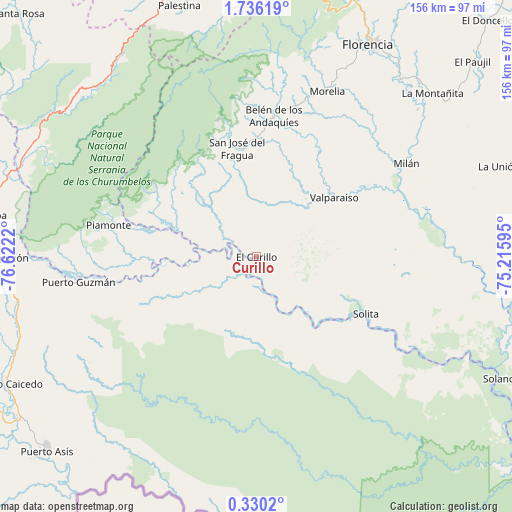
Curillo GPS coordinates[2]
1° 1' 59.772" North, 75° 55' 8.652" West
| Map corner | latitude | longitude |
|---|---|---|
| Upper-left | 1.73619°, | -76.6222° |
| Center: | 1.03327°, | -75.91907° |
| Lower-right: | 0.3302°, | -75.21595° |
| Map W x H: | 156.3×156.3 km | = 97.1×97.1mi |
| max Lat: | 13.38166° ⇑97.6% North |
| Curillo: | 1.03327° |
| min Lat: | ⇓2.4% South -4.21528° |
| min Long | Curillo | max Long |
| -81.70636° | -75.91907° | -67.06996° |
| W 21.5%⇐ | ⇒78.5% E |
Elevation
Elevation of Curillo is 230 m = 755 ft, and this is 919.3 m = 3016 ft below average elevation for this country.
| Max E: |
3342 m = 10965 ft | 73.1% |
| Avg. | 1149.3 m = 3771 ft | |
| Curillo | 230 m = 755 ft | |
Min E: |
1 m = 3 ft | 26.9% |
See also: Colombia elevation on elevation.city.
Geographical zone
Curillo is located in North Torrid zone (between Equator and Tropic of Cancer). Distance of Equator is 114.9 km =71.4 mi to South.| Distance of | km | miles | from Curillo |
|---|---|---|---|
| North Pole | 9892.2 | 6146.7 | to North |
| Arctic Circle | 7286.3 | 4527.5 | to North |
| Tropic Cancer | 2491 | 1547.8 | to North |
| Equator | 114.9 | 71.4 | to South |


Nearby cities:
15 places around Curillo: (largest is in red/bold)
• Albania
33.2 km =20.6 mi,  7°
7°
• Belén de los Andaquíes
43.1 km =26.8 mi, 6°
• Florencia
73.4 km =45.6 mi,  28°
28°
• La Montañita
73.1 km =45.4 mi,  47°
47°
• Milán
53.9 km =33.5 mi,  58°
58°
• Mocoa
82.6 km =51.3 mi,  279°
279°
• Morelia
54.9 km =34.1 mi,  23°
23°
• Palestina
80.4 km =50 mi,  342°
342°
• Piamonte
45.7 km =28.4 mi, 282°
• Puerto Guzmán
54.9 km =34.1 mi,  261°
261°
• Puerto Guzmán
74.5 km =46.3 mi, 264°
• San José del Fragua
33.8 km =21 mi,  349°
349°
• Solita
37.7 km =23.4 mi,  117°
117°
• Valparaíso
29.5 km =18.3 mi, 52°
• Villagarzón
78.7 km =48.9 mi,  270°
270°
Sources, notices
• [Note1] Compared only with cities in Colombia existing in our database
• [Src1] Map data: © OpenStreetMap contributors (CC-BY-SA)
• [Src2] Other city data from geonames.org with taken over terms of usage.
• [Src3] Geographical zone / Annual Mean Temperature by Robert A. Rohde @ Wikipedia
