Socotá geodata
Socotá (Boyacá) is a seat of a second-order administrative division; located in Colombia in America/Bogota (GMT-5) time zone. With population of 2,193 people, there are 776 cities with bigger population in this country. Compared to other cities in Colombia, 60.1% of cities are located further ↓South; 93.9% of cities are located further ←West and 87.3% of cities have lower elevation than Socotá. Note1


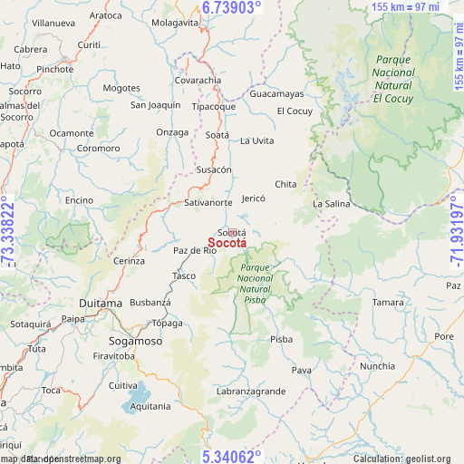
Socotá GPS coordinates[2]
6° 2' 25.008" North, 72° 38' 6.324" West
| Map corner | latitude | longitude |
|---|---|---|
| Upper-left | 6.73903°, | -73.33822° |
| Center: | 6.04028°, | -72.63509° |
| Lower-right: | 5.34062°, | -71.93197° |
| Map W x H: | 155.5×155.5 km | = 96.6×96.6mi |
| max Lat: | 13.38166° ⇑39.9% North |
| Socotá: | 6.04028° |
| min Lat: | ⇓60.1% South -4.21528° |
| min Long | Socotá | max Long |
| -81.70636° | -72.63509° | -67.06996° |
| W 93.9%⇐ | ⇒6.1% E |
Elevation
Elevation of Socotá is 2413 m = 7917 ft, and this is 1263.7 m = 4146 ft above average elevation for this country.
| Max E: |
3342 m = 10965 ft | 12.7% |
| Socotá | 2413 m 7917 ft | |
| Avg. | 1149.3 m = 3771 ft | |
Min E: |
1 m = 3 ft | 87.3% |
See also: Colombia elevation on elevation.city.
Geographical zone
Socotá is located in North Torrid zone (between Equator and Tropic of Cancer). Distance of Equator is 671.6 km =417.3 mi to South.| Distance of | km | miles | from Socotá |
|---|---|---|---|
| North Pole | 9335.4 | 5800.7 | to North |
| Arctic Circle | 6729.6 | 4181.6 | to North |
| Tropic Cancer | 1934.3 | 1201.9 | to North |
| Equator | 671.6 | 417.3 | to South |


Nearby cities:
15 places around Socotá: (largest is in red/bold)
• Belén
31.2 km =19.4 mi,  259°
259°
• Betéitiva
24 km =14.9 mi,  233°
233°
• Boavita
32.7 km =20.3 mi,  9°
9°
• Chita
24.3 km =15.1 mi,  46°
46°
• Gámeza
32.5 km =20.2 mi,  215°
215°
• Jericó
13.7 km =8.5 mi,  31°
31°
• La Uvita
32.2 km =20 mi, 14°
• Paz de Río
14.2 km =8.8 mi,  244°
244°
• Sativanorte
13 km =8.1 mi,  321°
321°
• Sativasur
11.3 km =7 mi,  299°
299°
• Socha
7.8 km =4.8 mi, 232°
• Socha Viejo
11 km =6.8 mi, 233°
• Susacón
21.9 km =13.6 mi,  343°
343°
• Tasco
21.6 km =13.4 mi, 227°
• Tutazá
24.5 km =15.2 mi,  267°
267°
Sources, notices
• [Note1] Compared only with cities in Colombia existing in our database
• [Src1] Map data: © OpenStreetMap contributors (CC-BY-SA)
• [Src2] Other city data from geonames.org with taken over terms of usage.
• [Src3] Geographical zone / Annual Mean Temperature by Robert A. Rohde @ Wikipedia
