Jericó geodata
Jericó (Boyacá) is a seat of a second-order administrative division; located in Colombia in America/Bogota (GMT-5) time zone. With population of 865 people, there are 966 cities with bigger population in this country. Compared to other cities in Colombia, 62% of cities are located further ↓South; 94.8% of cities are located further ←West and 99.5% of cities have lower elevation than Jericó. Note1


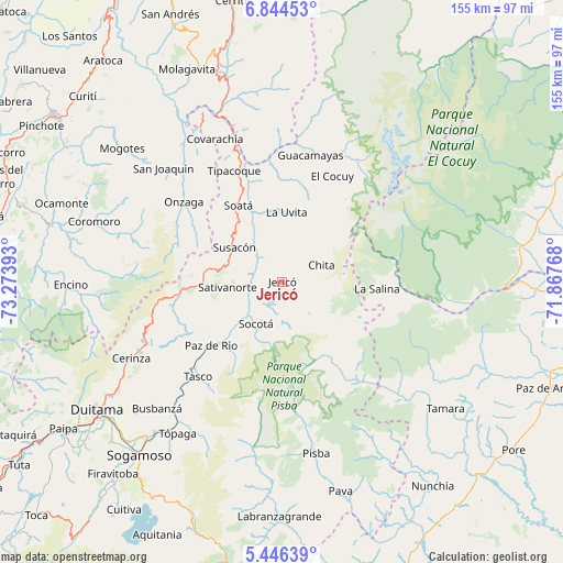
Jericó GPS coordinates[2]
6° 8' 45.312" North, 72° 34' 14.88" West
| Map corner | latitude | longitude |
|---|---|---|
| Upper-left | 6.84453°, | -73.27393° |
| Center: | 6.14592°, | -72.5708° |
| Lower-right: | 5.44639°, | -71.86768° |
| Map W x H: | 155.5×155.5 km | = 96.6×96.6mi |
| max Lat: | 13.38166° ⇑38% North |
| Jericó: | 6.14592° |
| min Lat: | ⇓62% South -4.21528° |
| min Long | Jericó | max Long |
| -81.70636° | -72.5708° | -67.06996° |
| W 94.8%⇐ | ⇒5.2% E |
Elevation
Elevation of Jericó is 3075 m = 10089 ft, and this is 1925.7 m = 6318 ft above average elevation for this country.
| Max E: |
3342 m = 10965 ft | 0.5% |
| Jericó | 3075 m 10089 ft | |
| Avg. | 1149.3 m = 3771 ft | |
Min E: |
1 m = 3 ft | 99.5% |
See also: Colombia elevation on elevation.city.
Geographical zone
Jericó is located in North Torrid zone (between Equator and Tropic of Cancer). Distance of Equator is 683.4 km =424.6 mi to South.| Distance of | km | miles | from Jericó |
|---|---|---|---|
| North Pole | 9323.7 | 5793.5 | to North |
| Arctic Circle | 6717.8 | 4174.2 | to North |
| Tropic Cancer | 1922.6 | 1194.6 | to North |
| Equator | 683.4 | 424.6 | to South |


Nearby cities:
15 places around Jericó: (largest is in red/bold)
• Boavita
20.6 km =12.8 mi,  355°
355°
• Chita
11.6 km =7.2 mi,  64°
64°
• El Cocuy
32.5 km =20.2 mi,  24°
24°
• La Salina
25.7 km =16 mi,  93°
93°
• La Uvita
19.4 km =12.1 mi,  2°
2°
• Paz de Río
26.8 km =16.7 mi,  227°
227°
• San Mateo
28.5 km =17.7 mi, 3°
• Sativanorte
15.4 km =9.6 mi,  264°
264°
• Sativasur
18.1 km =11.2 mi,  249°
249°
• Soatá
24.3 km =15.1 mi,  329°
329°
• Socha
21.2 km =13.2 mi,  218°
218°
• Socha Viejo
24.2 km =15 mi, 221°
• Socotá
13.7 km =8.5 mi,  211°
211°
• Susacón
16.2 km =10.1 mi,  305°
305°
• Tipacoque
33.3 km =20.7 mi,  336°
336°
Sources, notices
• [Note1] Compared only with cities in Colombia existing in our database
• [Src1] Map data: © OpenStreetMap contributors (CC-BY-SA)
• [Src2] Other city data from geonames.org with taken over terms of usage.
• [Src3] Geographical zone / Annual Mean Temperature by Robert A. Rohde @ Wikipedia
