Escazú geodata
Escazú (San José) is a populated place; located in Costa Rica in America/Costa_Rica (GMT-6) time zone. With population of 12,071 people, there are 48 cities with bigger population in this country. Compared to other cities in Costa Rica, 62.7% of cities are located further ↑North; 53% of cities are located further →East and 67.9% of cities have lower elevation than Escazú. Note1


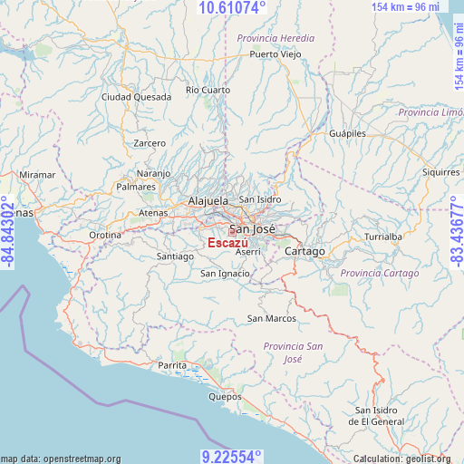
Escazú GPS coordinates[2]
9° 55' 7.932" North, 84° 8' 23.604" West
| Map corner | latitude | longitude |
|---|---|---|
| Upper-left | 10.61074°, | -84.84302° |
| Center: | 9.91887°, | -84.13989° |
| Lower-right: | 9.22554°, | -83.43677° |
| Map W x H: | 154×154 km | = 95.7×95.7mi |
| max Lat: | 11.07377° ⇑62.7% North |
| Escazú: | 9.91887° |
| min Lat: | ⇓37.3% South 8.53305° |
| min Long | Escazú | max Long |
| -85.64748° | -84.13989° | -82.62185° |
| W 47%⇐ | ⇒53% E |
Elevation
Elevation of Escazú is 1111 m = 3645 ft, and this is 376 m = 1234 ft above average elevation for this country.
| Max E: |
1844 m = 6050 ft | 32.1% |
| Escazú | 1111 m 3645 ft | |
| Avg. | 735 m = 2411 ft | |
Min E: |
7 m = 23 ft | 67.9% |
See also: Costa Rica elevation on elevation.city.
Geographical zone
Escazú is located in North Torrid zone (between Equator and Tropic of Cancer). Distance of Equator is 1102.9 km =685.3 mi to South.| Distance of | km | miles | from Escazú |
|---|---|---|---|
| North Pole | 8904.2 | 5532.8 | to North |
| Arctic Circle | 6298.3 | 3913.6 | to North |
| Tropic Cancer | 1503 | 933.9 | to North |
| Equator | 1102.9 | 685.3 | to South |


Nearby cities:
15 places around Escazú: (largest is in red/bold)
• Alajuelita
4.7 km =2.9 mi,  113°
113°
• Aserrí
8.5 km =5.3 mi,  142°
142°
• Calle Blancos
8.7 km =5.4 mi,  66°
66°
• Colima
7 km =4.3 mi,  59°
59°
• La Asunción
7.7 km =4.8 mi,  331°
331°
• Salitral
4.3 km =2.7 mi,  259°
259°
• San Antonio
8.6 km =5.3 mi, 326°
• San Felipe
4.1 km =2.5 mi, 112°
• San Francisco
8.3 km =5.2 mi,  7°
7°
• San José
6.4 km =4 mi,  75°
75°
• San Juan
7.8 km =4.8 mi,  54°
54°
• San Juan de Dios
7.6 km =4.7 mi,  127°
127°
• San Rafael
1 km =0.6 mi,  16°
16°
• San Rafael Arriba
8.4 km =5.2 mi,  124°
124°
• Santa Ana
4.9 km =3 mi,  288°
288°
Sources, notices
• [Note1] Compared only with cities in Costa Rica existing in our database
• [Src1] Map data: © OpenStreetMap contributors (CC-BY-SA)
• [Src2] Other city data from geonames.org with taken over terms of usage.
• [Src3] Geographical zone / Annual Mean Temperature by Robert A. Rohde @ Wikipedia
