Monterrey geodata
Monterrey (San José) is a seat of a third-order administrative division; located in Costa Rica in America/Costa_Rica (GMT-6) time zone. In our database, there are 124 cities with bigger population. Compared to other cities in Costa Rica, 86.6% of cities are located further ↑North; 51.5% of cities are located further ←West and 55.2% of cities have lower elevation than Monterrey. Note1


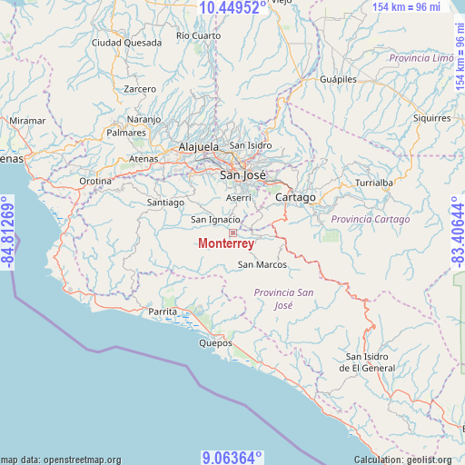
Monterrey GPS coordinates[2]
9° 45' 26.28" North, 84° 6' 34.416" West
| Map corner | latitude | longitude |
|---|---|---|
| Upper-left | 10.44952°, | -84.81269° |
| Center: | 9.7573°, | -84.10956° |
| Lower-right: | 9.06364°, | -83.40644° |
| Map W x H: | 154.1×154.1 km | = 95.8×95.8mi |
| max Lat: | 11.07377° ⇑86.6% North |
| Monterrey: | 9.7573° |
| min Lat: | ⇓13.4% South 8.53305° |
| min Long | Monterrey | max Long |
| -85.64748° | -84.10956° | -82.62185° |
| W 51.5%⇐ | ⇒48.5% E |
Elevation
Elevation of Monterrey is 987 m = 3238 ft, and this is 252 m = 827 ft above average elevation for this country.
| Max E: |
1844 m = 6050 ft | 44.8% |
| Monterrey | 987 m 3238 ft | |
| Avg. | 735 m = 2411 ft | |
Min E: |
7 m = 23 ft | 55.2% |
See also: Costa Rica elevation on elevation.city.
Geographical zone
Monterrey is located in North Torrid zone (between Equator and Tropic of Cancer). Distance of Equator is 1084.9 km =674.1 mi to South.| Distance of | km | miles | from Monterrey |
|---|---|---|---|
| North Pole | 8922.2 | 5544 | to North |
| Arctic Circle | 6316.3 | 3924.8 | to North |
| Tropic Cancer | 1521 | 945.1 | to North |
| Equator | 1084.9 | 674.1 | to South |


Nearby cities:
15 places around Monterrey: (largest is in red/bold)
• Alajuelita
16.1 km =10 mi,  3°
3°
• Aserrí
11.4 km =7.1 mi,  9°
9°
• Pacayas
8.8 km =5.5 mi,  50°
50°
• Palmichal
13.7 km =8.5 mi,  310°
310°
• Patarrá
16 km =9.9 mi,  30°
30°
• Salitrillos
10.8 km =6.7 mi, 11°
• San Felipe
16.4 km =10.2 mi, 1°
• San Ignacio
7.3 km =4.5 mi, 308°
• San Juan de Dios
13.6 km =8.5 mi, 11°
• San Marcos
14.6 km =9.1 mi,  137°
137°
• San Miguel
13.7 km =8.5 mi,  22°
22°
• San Pablo
11.2 km =7 mi, 137°
• San Rafael Arriba
13.6 km =8.5 mi, 15°
• Tejar
13.7 km =8.5 mi,  264°
264°
• Tobosi
16.5 km =10.3 mi,  56°
56°
Sources, notices
• [Note1] Compared only with cities in Costa Rica existing in our database
• [Src1] Map data: © OpenStreetMap contributors (CC-BY-SA)
• [Src2] Other city data from geonames.org with taken over terms of usage.
• [Src3] Geographical zone / Annual Mean Temperature by Robert A. Rohde @ Wikipedia
