San Ignacio geodata
San Ignacio (San José) is a populated place; located in Costa Rica in America/Costa_Rica (GMT-6) time zone. With population of 3,072 people, there are 94 cities with bigger population in this country. Compared to other cities in Costa Rica, 85.1% of cities are located further ↑North; 55.2% of cities are located further →East and 64.9% of cities have lower elevation than San Ignacio. Note1


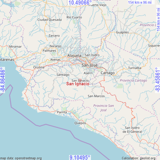
San Ignacio GPS coordinates[2]
9° 47' 54.708" North, 84° 9' 42.228" West
| Map corner | latitude | longitude |
|---|---|---|
| Upper-left | 10.49066°, | -84.86486° |
| Center: | 9.79853°, | -84.16173° |
| Lower-right: | 9.10495°, | -83.45861° |
| Map W x H: | 154.1×154.1 km | = 95.8×95.8mi |
| max Lat: | 11.07377° ⇑85.1% North |
| San Ignacio: | 9.79853° |
| min Lat: | ⇓14.9% South 8.53305° |
| min Long | San Ignacio | max Long |
| -85.64748° | -84.16173° | -82.62185° |
| W 44.8%⇐ | ⇒55.2% E |
Elevation
Elevation of San Ignacio is 1097 m = 3599 ft, and this is 362 m = 1188 ft above average elevation for this country.
| Max E: |
1844 m = 6050 ft | 35.1% |
| San Ignacio | 1097 m 3599 ft | |
| Avg. | 735 m = 2411 ft | |
Min E: |
7 m = 23 ft | 64.9% |
See also: Costa Rica elevation on elevation.city.
Geographical zone
San Ignacio is located in North Torrid zone (between Equator and Tropic of Cancer). Distance of Equator is 1089.5 km =677 mi to South.| Distance of | km | miles | from San Ignacio |
|---|---|---|---|
| North Pole | 8917.6 | 5541.1 | to North |
| Arctic Circle | 6311.7 | 3921.9 | to North |
| Tropic Cancer | 1516.4 | 942.2 | to North |
| Equator | 1089.5 | 677 | to South |


Nearby cities:
15 places around San Ignacio: (largest is in red/bold)
• Alajuelita
13.3 km =8.3 mi,  30°
30°
• Aserrí
10.1 km =6.3 mi,  48°
48°
• Escazú
13.6 km =8.5 mi,  10°
10°
• Monterrey
7.3 km =4.5 mi,  128°
128°
• Pacayas
12.5 km =7.8 mi,  85°
85°
• Palmichal
6.4 km =4 mi,  312°
312°
• Salitral
12.7 km =7.9 mi,  351°
351°
• Salitrillos
9.8 km =6.1 mi, 52°
• San Felipe
13.3 km =8.3 mi, 27°
• San Juan de Dios
12.2 km =7.6 mi,  43°
43°
• San Miguel
13.7 km =8.5 mi, 53°
• San Rafael
14.6 km =9.1 mi, 10°
• San Rafael Abajo
14.5 km =9 mi,  284°
284°
• San Rafael Arriba
12.7 km =7.9 mi, 47°
• Tejar
9.8 km =6.1 mi,  233°
233°
Sources, notices
• [Note1] Compared only with cities in Costa Rica existing in our database
• [Src1] Map data: © OpenStreetMap contributors (CC-BY-SA)
• [Src2] Other city data from geonames.org with taken over terms of usage.
• [Src3] Geographical zone / Annual Mean Temperature by Robert A. Rohde @ Wikipedia
