Puerto Padre geodata
Puerto Padre (Las Tunas) is a seat of a second-order administrative division; located in Cuba in America/Havana (GMT-4) time zone. With population of 76,838 people, there are 27 cities with bigger population in this country. Compared to other cities in Cuba, 72.4% of cities are located further ↑North; 82.3% of cities are located further ←West and 72.9% of cities have higher elevation than Puerto Padre. Note1


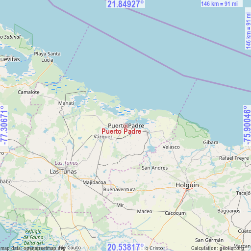
Puerto Padre GPS coordinates[2]
21° 11' 42.612" North, 76° 36' 12.888" West
| Map corner | latitude | longitude |
|---|---|---|
| Upper-left | 21.84927°, | -77.30671° |
| Center: | 21.19517°, | -76.60358° |
| Lower-right: | 20.53817°, | -75.90046° |
| Map W x H: | 145.8×145.8 km | = 90.6×90.6mi |
| max Lat: | 23.15917° ⇑72.4% North |
| Puerto Padre: | 21.19517° |
| min Lat: | ⇓27.6% South 19.90553° |
| min Long | Puerto Padre | max Long |
| -84.28599° | -76.60358° | -74.15181° |
| W 82.3%⇐ | ⇒17.7% E |
Elevation
Elevation of Puerto Padre is 26 m = 85 ft, and this is 42.6 m = 140 ft below average elevation for this country.
| Max E: |
761 m = 2497 ft | 72.9% |
| Avg. | 68.6 m = 225 ft | |
| Puerto Padre | 26 m = 85 ft | |
Min E: |
3 m = 10 ft | 27.1% |
See also: Puerto Padre elevation on elevation.city.
Geographical zone
Puerto Padre is located in North Torrid zone (between Equator and Tropic of Cancer). Distance of this Northern Tropic circle is 249.2 km =154.8 mi to North.| Distance of | km | miles | from Puerto Padre |
|---|---|---|---|
| North Pole | 7650.4 | 4753.7 | to North |
| Arctic Circle | 5044.5 | 3134.5 | to North |
| Tropic Cancer | 249.2 | 154.8 | to North |
| Equator | 2356.7 | 1464.4 | to South |


Nearby cities:
15 places around Puerto Padre: (largest is in red/bold)
• Báguanos
77.7 km =48.3 mi,  129°
129°
• Cacocum
58.5 km =36.4 mi,  150°
150°
• Calixto
41.3 km =25.7 mi,  222°
222°
• Cauto Cristo
72.2 km =44.9 mi,  169°
169°
• Gibara
49.9 km =31 mi,  100°
100°
• Guáimaro
79 km =49.1 mi,  258°
258°
• Holguín
49.2 km =30.6 mi, 134°
• Jesús Menéndez
13.4 km =8.3 mi,  106°
106°
• Jobabo
40.3 km =25 mi, 128°
• Jobabo
77.3 km =48 mi,  245°
245°
• Las Tunas
44.4 km =27.6 mi,  234°
234°
• Manatí
36.6 km =22.7 mi,  290°
290°
• Nuevitas
78.8 km =49 mi,  299°
299°
• Río Cauto
77.8 km =48.3 mi,  204°
204°
• Santa Lucía
65.8 km =40.9 mi, 106°
Sources, notices
• [Note1] Compared only with cities in Cuba existing in our database
• [Src1] Map data: © OpenStreetMap contributors (CC-BY-SA)
• [Src2] Other city data from geonames.org with taken over terms of usage.
• [Src3] Geographical zone / Annual Mean Temperature by Robert A. Rohde @ Wikipedia
