Gibara geodata
Gibara (Holguín) is a seat of a second-order administrative division; located in Cuba in America/Havana (GMT-4) time zone. With population of 27,603 people, there are 81 cities with bigger population in this country. Compared to other cities in Cuba, 73.5% of cities are located further ↑North; 87.8% of cities are located further ←West and 76.2% of cities have higher elevation than Gibara. Note1


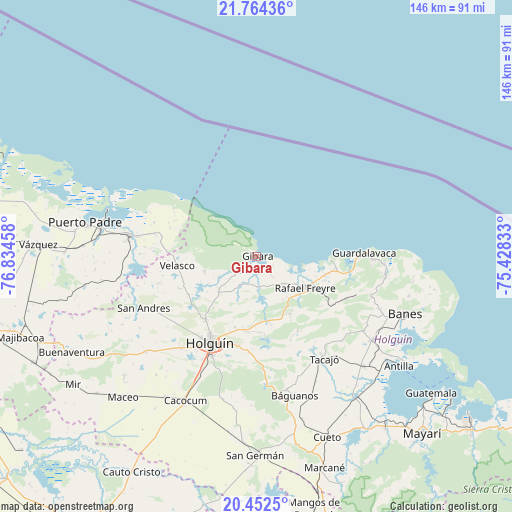
Gibara GPS coordinates[2]
21° 6' 35.568" North, 76° 7' 53.22" West
| Map corner | latitude | longitude |
|---|---|---|
| Upper-left | 21.76436°, | -76.83458° |
| Center: | 21.10988°, | -76.13145° |
| Lower-right: | 20.4525°, | -75.42833° |
| Map W x H: | 145.9×145.9 km | = 90.7×90.7mi |
| max Lat: | 23.15917° ⇑73.5% North |
| Gibara: | 21.10988° |
| min Lat: | ⇓26.5% South 19.90553° |
| min Long | Gibara | max Long |
| -84.28599° | -76.13145° | -74.15181° |
| W 87.8%⇐ | ⇒12.2% E |
Elevation
Elevation of Gibara is 23 m = 75 ft, and this is 45.6 m = 150 ft below average elevation for this country.
| Max E: |
761 m = 2497 ft | 76.2% |
| Avg. | 68.6 m = 225 ft | |
| Gibara | 23 m = 75 ft | |
Min E: |
3 m = 10 ft | 23.8% |
See also: Cuba elevation on elevation.city.
Geographical zone
Gibara is located in North Torrid zone (between Equator and Tropic of Cancer). Distance of this Northern Tropic circle is 258.7 km =160.7 mi to North.| Distance of | km | miles | from Gibara |
|---|---|---|---|
| North Pole | 7659.9 | 4759.6 | to North |
| Arctic Circle | 5054 | 3140.4 | to North |
| Tropic Cancer | 258.7 | 160.7 | to North |
| Equator | 2347.2 | 1458.5 | to South |


Nearby cities:
15 places around Gibara: (largest is in red/bold)
• Antilla
51.5 km =32 mi,  127°
127°
• Banes
45.6 km =28.3 mi,  111°
111°
• Báguanos
41.4 km =25.7 mi,  164°
164°
• Cacocum
46 km =28.6 mi,  205°
205°
• Calixto
79.6 km =49.5 mi,  254°
254°
• Cauto Cristo
71 km =44.1 mi, 209°
• Cueto
55.4 km =34.4 mi, 157°
• Holguín
28.3 km =17.6 mi, 208°
• Jesús Menéndez
36.5 km =22.7 mi,  279°
279°
• Jobabo
23.4 km =14.5 mi,  228°
228°
• Manatí
86.1 km =53.5 mi,  285°
285°
• Mayarí
69.1 km =42.9 mi,  137°
137°
• Puerto Padre
49.9 km =31 mi, 280°
• San Germán
56.7 km =35.2 mi,  180°
180°
• Santa Lucía
16.8 km =10.4 mi,  122°
122°
Sources, notices
• [Note1] Compared only with cities in Cuba existing in our database
• [Src1] Map data: © OpenStreetMap contributors (CC-BY-SA)
• [Src2] Other city data from geonames.org with taken over terms of usage.
• [Src3] Geographical zone / Annual Mean Temperature by Robert A. Rohde @ Wikipedia
