Manatí geodata
Manatí (Las Tunas) is a seat of a second-order administrative division; located in Cuba in America/Havana (GMT-4) time zone. With population of 13,278 people, there are 132 cities with bigger population in this country. Compared to other cities in Cuba, 69.6% of cities are located further ↑North; 79.6% of cities are located further ←West and 86.2% of cities have higher elevation than Manatí. Note1


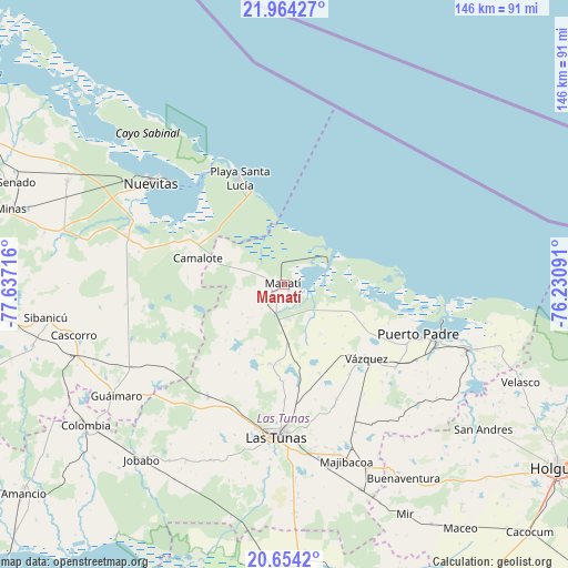
Manatí GPS coordinates[2]
21° 18' 38.52" North, 76° 56' 2.508" West
| Map corner | latitude | longitude |
|---|---|---|
| Upper-left | 21.96427°, | -77.63716° |
| Center: | 21.3107°, | -76.93403° |
| Lower-right: | 20.6542°, | -76.23091° |
| Map W x H: | 145.7×145.7 km | = 90.5×90.5mi |
| max Lat: | 23.15917° ⇑69.6% North |
| Manatí: | 21.3107° |
| min Lat: | ⇓30.4% South 19.90553° |
| min Long | Manatí | max Long |
| -84.28599° | -76.93403° | -74.15181° |
| W 79.6%⇐ | ⇒20.4% E |
Elevation
Elevation of Manatí is 14 m = 46 ft, and this is 54.6 m = 179 ft below average elevation for this country.
| Max E: |
761 m = 2497 ft | 86.2% |
| Avg. | 68.6 m = 225 ft | |
| Manatí | 14 m = 46 ft | |
Min E: |
3 m = 10 ft | 13.8% |
See also: Cuba elevation on elevation.city.
Geographical zone
Manatí is located in North Torrid zone (between Equator and Tropic of Cancer). Distance of this Northern Tropic circle is 236.4 km =146.9 mi to North.| Distance of | km | miles | from Manatí |
|---|---|---|---|
| North Pole | 7637.5 | 4745.7 | to North |
| Arctic Circle | 5031.6 | 3126.5 | to North |
| Tropic Cancer | 236.4 | 146.9 | to North |
| Equator | 2369.5 | 1472.3 | to South |


Nearby cities:
15 places around Manatí: (largest is in red/bold)
• Amancio
86.5 km =53.7 mi,  230°
230°
• Calixto
43.9 km =27.3 mi,  171°
171°
• Colombia
62.4 km =38.8 mi, 234°
• Gibara
86.1 km =53.5 mi,  105°
105°
• Guáimaro
51.8 km =32.2 mi,  236°
236°
• Holguín
84 km =52.2 mi,  124°
124°
• Jesús Menéndez
50 km =31.1 mi, 109°
• Jobabo
57.6 km =35.8 mi,  218°
218°
• Jobabo
76 km =47.2 mi, 119°
• Las Tunas
38.8 km =24.1 mi,  182°
182°
• Minas
72.7 km =45.2 mi,  285°
285°
• Nuevitas
43.1 km =26.8 mi,  307°
307°
• Puerto Padre
36.6 km =22.7 mi, 110°
• Río Cauto
83.5 km =51.9 mi, 178°
• Sibanicú
61.9 km =38.5 mi,  262°
262°
Sources, notices
• [Note1] Compared only with cities in Cuba existing in our database
• [Src1] Map data: © OpenStreetMap contributors (CC-BY-SA)
• [Src2] Other city data from geonames.org with taken over terms of usage.
• [Src3] Geographical zone / Annual Mean Temperature by Robert A. Rohde @ Wikipedia
