Holguín geodata
Holguín is a seat of a first-order administrative division; located in Cuba in America/Havana (GMT-4) time zone. With population of 319,102 people, there are 3 cities with bigger population in this country. Compared to other cities in Cuba, 79% of cities are located further ↑North; 86.2% of cities are located further ←West and 93.9% of cities have lower elevation than Holguín. Note1


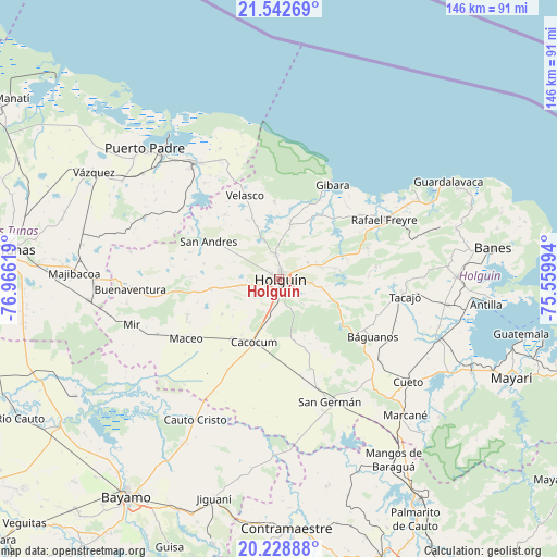
Holguín GPS coordinates[2]
20° 53' 13.992" North, 76° 15' 47.016" West
| Map corner | latitude | longitude |
|---|---|---|
| Upper-left | 21.54269°, | -76.96619° |
| Center: | 20.88722°, | -76.26306° |
| Lower-right: | 20.22888°, | -75.55994° |
| Map W x H: | 146.1×146.1 km | = 90.8×90.8mi |
| max Lat: | 23.15917° ⇑79% North |
| Holguín: | 20.88722° |
| min Lat: | ⇓21% South 19.90553° |
| min Long | Holguín | max Long |
| -84.28599° | -76.26306° | -74.15181° |
| W 86.2%⇐ | ⇒13.8% E |
Elevation
Elevation of Holguín is 146 m = 479 ft, and this is 77.4 m = 254 ft above average elevation for this country.
| Max E: |
761 m = 2497 ft | 6.1% |
| Holguín | 146 m 479 ft | |
| Avg. | 68.6 m = 225 ft | |
Min E: |
3 m = 10 ft | 93.9% |
See also: Holguín elevation on elevation.city.
Geographical zone
Holguín is located in North Torrid zone (between Equator and Tropic of Cancer). Distance of this Northern Tropic circle is 283.5 km =176.2 mi to North.| Distance of | km | miles | from Holguín |
|---|---|---|---|
| North Pole | 7684.6 | 4775 | to North |
| Arctic Circle | 5078.7 | 3155.8 | to North |
| Tropic Cancer | 283.5 | 176.2 | to North |
| Equator | 2322.4 | 1443.1 | to South |


Nearby cities:
15 places around Holguín: (largest is in red/bold)
• Antilla
55.2 km =34.3 mi,  96°
96°
• Banes
56.8 km =35.3 mi,  81°
81°
• Báguanos
28.9 km =18 mi,  121°
121°
• Cacocum
17.9 km =11.1 mi,  201°
201°
• Calixto
63.3 km =39.3 mi,  273°
273°
• Cauto Cristo
42.7 km =26.5 mi,  210°
210°
• Contramaestre
65.5 km =40.7 mi,  178°
178°
• Cueto
43.7 km =27.2 mi,  127°
127°
• Gibara
28.3 km =17.6 mi,  28°
28°
• Jesús Menéndez
37.8 km =23.5 mi,  323°
323°
• Jiguaní
60.2 km =37.4 mi, 196°
• Jobabo
9.9 km =6.2 mi,  337°
337°
• Puerto Padre
49.2 km =30.6 mi,  314°
314°
• San Germán
34.6 km =21.5 mi,  157°
157°
• Santa Lucía
32.1 km =19.9 mi,  60°
60°
Sources, notices
• [Note1] Compared only with cities in Cuba existing in our database
• [Src1] Map data: © OpenStreetMap contributors (CC-BY-SA)
• [Src2] Other city data from geonames.org with taken over terms of usage.
• [Src3] Geographical zone / Annual Mean Temperature by Robert A. Rohde @ Wikipedia
