Báguanos geodata
Báguanos (Holguín) is a seat of a second-order administrative division; located in Cuba in America/Havana (GMT-4) time zone. In our database, there are 154 cities with bigger population. Compared to other cities in Cuba, 80.7% of cities are located further ↑North; 88.4% of cities are located further ←West and 74% of cities have lower elevation than Báguanos. Note1


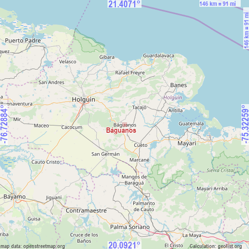
Báguanos GPS coordinates[2]
20° 45' 3.708" North, 76° 1' 32.556" West
| Map corner | latitude | longitude |
|---|---|---|
| Upper-left | 21.4071°, | -76.72884° |
| Center: | 20.75103°, | -76.02571° |
| Lower-right: | 20.0921°, | -75.32259° |
| Map W x H: | 146.2×146.2 km | = 90.8×90.8mi |
| max Lat: | 23.15917° ⇑80.7% North |
| Báguanos: | 20.75103° |
| min Lat: | ⇓19.3% South 19.90553° |
| min Long | Báguanos | max Long |
| -84.28599° | -76.02571° | -74.15181° |
| W 88.4%⇐ | ⇒11.6% E |
Elevation
Elevation of Báguanos is 84 m = 276 ft, and this is 15.4 m = 51 ft above average elevation for this country.
| Max E: |
761 m = 2497 ft | 26% |
| Báguanos | 84 m 276 ft | |
| Avg. | 68.6 m = 225 ft | |
Min E: |
3 m = 10 ft | 74% |
See also: Cuba elevation on elevation.city.
Geographical zone
Báguanos is located in North Torrid zone (between Equator and Tropic of Cancer). Distance of this Northern Tropic circle is 298.6 km =185.5 mi to North.| Distance of | km | miles | from Báguanos |
|---|---|---|---|
| North Pole | 7699.8 | 4784.4 | to North |
| Arctic Circle | 5093.9 | 3165.2 | to North |
| Tropic Cancer | 298.6 | 185.5 | to North |
| Equator | 2307.3 | 1433.7 | to South |


Nearby cities:
15 places around Báguanos: (largest is in red/bold)
• Antilla
31.4 km =19.5 mi,  73°
73°
• Banes
39.3 km =24.4 mi,  53°
53°
• Cacocum
31.2 km =19.4 mi,  267°
267°
• Cauto Cristo
51.3 km =31.9 mi,  245°
245°
• Contramaestre
55.2 km =34.3 mi,  204°
204°
• Cueto
15.2 km =9.4 mi,  138°
138°
• Gibara
41.4 km =25.7 mi,  344°
344°
• Holguín
28.9 km =18 mi,  301°
301°
• Jiguaní
59.7 km =37.1 mi,  224°
224°
• Jobabo
37.4 km =23.2 mi,  310°
310°
• Mayarí
37.6 km =23.4 mi,  106°
106°
• Palma Soriano
60.1 km =37.3 mi,  176°
176°
• San Germán
20.2 km =12.6 mi,  213°
213°
• San Luis
65.2 km =40.5 mi,  163°
163°
• Santa Lucía
31.1 km =19.3 mi,  5°
5°
Sources, notices
• [Note1] Compared only with cities in Cuba existing in our database
• [Src1] Map data: © OpenStreetMap contributors (CC-BY-SA)
• [Src2] Other city data from geonames.org with taken over terms of usage.
• [Src3] Geographical zone / Annual Mean Temperature by Robert A. Rohde @ Wikipedia
