La Sierpe geodata
La Sierpe (Sancti Spíritus) is a seat of a second-order administrative division; located in Cuba in America/Havana (GMT-4) time zone. With population of 16,937 people, there are 119 cities with bigger population in this country. Compared to other cities in Cuba, 64.1% of cities are located further ↑North; 57.5% of cities are located further ←West and 56.9% of cities have higher elevation than La Sierpe. Note1


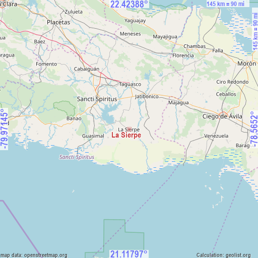
La Sierpe GPS coordinates[2]
21° 46' 20.676" North, 79° 16' 5.952" West
| Map corner | latitude | longitude |
|---|---|---|
| Upper-left | 22.42388°, | -79.97145° |
| Center: | 21.77241°, | -79.26832° |
| Lower-right: | 21.11797°, | -78.5652° |
| Map W x H: | 145.2×145.2 km | = 90.2×90.2mi |
| max Lat: | 23.15917° ⇑64.1% North |
| La Sierpe: | 21.77241° |
| min Lat: | ⇓35.9% South 19.90553° |
| min Long | La Sierpe | max Long |
| -84.28599° | -79.26832° | -74.15181° |
| W 57.5%⇐ | ⇒42.5% E |
Elevation
Elevation of La Sierpe is 43 m = 141 ft, and this is 25.6 m = 84 ft below average elevation for this country.
| Max E: |
761 m = 2497 ft | 56.9% |
| Avg. | 68.6 m = 225 ft | |
| La Sierpe | 43 m = 141 ft | |
Min E: |
3 m = 10 ft | 43.1% |
See also: Cuba elevation on elevation.city.
Geographical zone
La Sierpe is located in North Torrid zone (between Equator and Tropic of Cancer). Distance of this Northern Tropic circle is 185.1 km =115 mi to North.| Distance of | km | miles | from La Sierpe |
|---|---|---|---|
| North Pole | 7586.2 | 4713.8 | to North |
| Arctic Circle | 4980.3 | 3094.6 | to North |
| Tropic Cancer | 185.1 | 115 | to North |
| Equator | 2420.9 | 1504.3 | to South |


Nearby cities:
15 places around La Sierpe: (largest is in red/bold)
• Cabaiguán
41.4 km =25.7 mi,  325°
325°
• Chambas
59.7 km =37.1 mi,  37°
37°
• Ciego de Ávila
52.8 km =32.8 mi,  81°
81°
• Ciro Redondo
64.4 km =40 mi,  64°
64°
• Condado
60.2 km =37.4 mi,  281°
281°
• Florencia
51.5 km =32 mi, 36°
• Fomento
59.6 km =37 mi,  308°
308°
• Guayos
36.7 km =22.8 mi, 327°
• Jatibonico
21.6 km =13.4 mi,  28°
28°
• Majagua
31.7 km =19.7 mi, 59°
• Sancti Spíritus
25.1 km =15.6 mi, 314°
• Taguasco
25.5 km =15.8 mi,  1°
1°
• Venezuela
49.2 km =30.6 mi,  94°
94°
• Yaguajay
61.7 km =38.3 mi, 3°
• Zaza del Medio
27 km =16.8 mi,  337°
337°
Sources, notices
• [Note1] Compared only with cities in Cuba existing in our database
• [Src1] Map data: © OpenStreetMap contributors (CC-BY-SA)
• [Src2] Other city data from geonames.org with taken over terms of usage.
• [Src3] Geographical zone / Annual Mean Temperature by Robert A. Rohde @ Wikipedia
