Fomento geodata
Fomento (Sancti Spíritus) is a seat of a second-order administrative division; located in Cuba in America/Havana (GMT-4) time zone. With population of 19,991 people, there are 107 cities with bigger population in this country. Compared to other cities in Cuba, 54.7% of cities are located further ↑North; 53% of cities are located further ←West and 89% of cities have lower elevation than Fomento. Note1


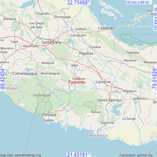
Fomento GPS coordinates[2]
22° 6' 17.1" North, 79° 43' 17.076" West
| Map corner | latitude | longitude |
|---|---|---|
| Upper-left | 22.75468°, | -80.42454° |
| Center: | 22.10475°, | -79.72141° |
| Lower-right: | 21.45181°, | -79.01829° |
| Map W x H: | 144.9×144.9 km | = 90×90mi |
| max Lat: | 23.15917° ⇑54.7% North |
| Fomento: | 22.10475° |
| min Lat: | ⇓45.3% South 19.90553° |
| min Long | Fomento | max Long |
| -84.28599° | -79.72141° | -74.15181° |
| W 53%⇐ | ⇒47% E |
Elevation
Elevation of Fomento is 127 m = 417 ft, and this is 58.4 m = 192 ft above average elevation for this country.
| Max E: |
761 m = 2497 ft | 11% |
| Fomento | 127 m 417 ft | |
| Avg. | 68.6 m = 225 ft | |
Min E: |
3 m = 10 ft | 89% |
See also: Cuba elevation on elevation.city.
Geographical zone
Fomento is located in North Torrid zone (between Equator and Tropic of Cancer). Distance of this Northern Tropic circle is 148.1 km =92 mi to North.| Distance of | km | miles | from Fomento |
|---|---|---|---|
| North Pole | 7549.2 | 4690.9 | to North |
| Arctic Circle | 4943.4 | 3071.7 | to North |
| Tropic Cancer | 148.1 | 92 | to North |
| Equator | 2457.8 | 1527.2 | to South |


Nearby cities:
15 places around Fomento: (largest is in red/bold)
• Cabaiguán
23.3 km =14.5 mi,  97°
97°
• Camajuaní
40 km =24.9 mi,  359°
359°
• Camajuaní
42.2 km =26.2 mi, 356°
• Condado
28.2 km =17.5 mi,  205°
205°
• Cumanayagua
49.9 km =31 mi,  276°
276°
• Guayos
27.5 km =17.1 mi, 102°
• Manicaragua
27 km =16.8 mi, 280°
• Placetas
24 km =14.9 mi,  16°
16°
• Remedios
47 km =29.2 mi, 22°
• Sancti Spíritus
34.7 km =21.6 mi,  124°
124°
• Santa Clara
41.9 km =26 mi,  323°
323°
• Taguasco
48.5 km =30.1 mi, 103°
• Topes de Collantes
37.2 km =23.1 mi,  235°
235°
• Trinidad
43.2 km =26.8 mi,  218°
218°
• Zaza del Medio
38.5 km =23.9 mi,  108°
108°
Sources, notices
• [Note1] Compared only with cities in Cuba existing in our database
• [Src1] Map data: © OpenStreetMap contributors (CC-BY-SA)
• [Src2] Other city data from geonames.org with taken over terms of usage.
• [Src3] Geographical zone / Annual Mean Temperature by Robert A. Rohde @ Wikipedia
