Yaguajay geodata
Yaguajay (Sancti Spíritus) is a seat of a second-order administrative division; located in Cuba in America/Havana (GMT-4) time zone. With population of 42,218 people, there are 59 cities with bigger population in this country. Compared to other cities in Cuba, 53% of cities are located further ↓South; 58.6% of cities are located further ←West and 67.4% of cities have higher elevation than Yaguajay. Note1


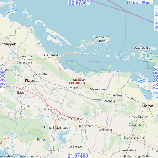
Yaguajay GPS coordinates[2]
22° 19' 36.876" North, 79° 14' 8.412" West
| Map corner | latitude | longitude |
|---|---|---|
| Upper-left | 22.9758°, | -79.9388° |
| Center: | 22.32691°, | -79.23567° |
| Lower-right: | 21.67499°, | -78.53255° |
| Map W x H: | 144.6×144.6 km | = 89.9×89.9mi |
| max Lat: | 23.15917° ⇑47% North |
| Yaguajay: | 22.32691° |
| min Lat: | ⇓53% South 19.90553° |
| min Long | Yaguajay | max Long |
| -84.28599° | -79.23567° | -74.15181° |
| W 58.6%⇐ | ⇒41.4% E |
Elevation
Elevation of Yaguajay is 29 m = 95 ft, and this is 39.6 m = 130 ft below average elevation for this country.
| Max E: |
761 m = 2497 ft | 67.4% |
| Avg. | 68.6 m = 225 ft | |
| Yaguajay | 29 m = 95 ft | |
Min E: |
3 m = 10 ft | 32.6% |
See also: Yaguajay elevation on elevation.city.
Geographical zone
Yaguajay is located in North Torrid zone (between Equator and Tropic of Cancer). Distance of this Northern Tropic circle is 123.4 km =76.7 mi to North.| Distance of | km | miles | from Yaguajay |
|---|---|---|---|
| North Pole | 7524.5 | 4675.5 | to North |
| Arctic Circle | 4918.7 | 3056.3 | to North |
| Tropic Cancer | 123.4 | 76.7 | to North |
| Equator | 2482.5 | 1542.6 | to South |


Nearby cities:
15 places around Yaguajay: (largest is in red/bold)
• Cabaiguán
38.6 km =24 mi,  224°
224°
• Caibarién
32 km =19.9 mi,  312°
312°
• Camajuaní
52.4 km =32.6 mi,  287°
287°
• Camajuaní
55.7 km =34.6 mi, 288°
• Chambas
36.3 km =22.6 mi,  113°
113°
• Florencia
33.7 km =20.9 mi,  126°
126°
• Fomento
55.8 km =34.7 mi,  243°
243°
• Guayos
38.6 km =24 mi, 216°
• Jatibonico
43.2 km =26.8 mi,  170°
170°
• Majagua
51.5 km =32 mi,  152°
152°
• Placetas
43.1 km =26.8 mi,  267°
267°
• Remedios
36.9 km =22.9 mi,  300°
300°
• Sancti Spíritus
49 km =30.4 mi,  205°
205°
• Taguasco
36.2 km =22.5 mi,  184°
184°
• Zaza del Medio
39.1 km =24.3 mi,  200°
200°
Sources, notices
• [Note1] Compared only with cities in Cuba existing in our database
• [Src1] Map data: © OpenStreetMap contributors (CC-BY-SA)
• [Src2] Other city data from geonames.org with taken over terms of usage.
• [Src3] Geographical zone / Annual Mean Temperature by Robert A. Rohde @ Wikipedia
