Guayos geodata
Guayos (Sancti Spíritus) is a populated place; located in Cuba in America/Havana (GMT-4) time zone. With population of 15,000 people, there are 127 cities with bigger population in this country. Compared to other cities in Cuba, 56.4% of cities are located further ↑North; 55.8% of cities are located further ←West and 82.9% of cities have lower elevation than Guayos. Note1


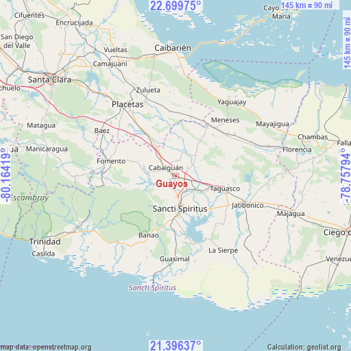
Guayos GPS coordinates[2]
22° 2' 58.416" North, 79° 27' 39.816" West
| Map corner | latitude | longitude |
|---|---|---|
| Upper-left | 22.69975°, | -80.16419° |
| Center: | 22.04956°, | -79.46106° |
| Lower-right: | 21.39637°, | -78.75794° |
| Map W x H: | 144.9×144.9 km | = 90×90mi |
| max Lat: | 23.15917° ⇑56.4% North |
| Guayos: | 22.04956° |
| min Lat: | ⇓43.6% South 19.90553° |
| min Long | Guayos | max Long |
| -84.28599° | -79.46106° | -74.15181° |
| W 55.8%⇐ | ⇒44.2% E |
Elevation
Elevation of Guayos is 107 m = 351 ft, and this is 38.4 m = 126 ft above average elevation for this country.
| Max E: |
761 m = 2497 ft | 17.1% |
| Guayos | 107 m 351 ft | |
| Avg. | 68.6 m = 225 ft | |
Min E: |
3 m = 10 ft | 82.9% |
See also: Cuba elevation on elevation.city.
Geographical zone
Guayos is located in North Torrid zone (between Equator and Tropic of Cancer). Distance of this Northern Tropic circle is 154.2 km =95.8 mi to North.| Distance of | km | miles | from Guayos |
|---|---|---|---|
| North Pole | 7555.4 | 4694.7 | to North |
| Arctic Circle | 4949.5 | 3075.5 | to North |
| Tropic Cancer | 154.2 | 95.8 | to North |
| Equator | 2451.7 | 1523.4 | to South |


Nearby cities:
15 places around Guayos: (largest is in red/bold)
• Cabaiguán
4.9 km =3 mi,  311°
311°
• Caibarién
52.3 km =32.5 mi,  359°
359°
• Camajuaní
53.5 km =33.2 mi,  329°
329°
• Condado
43.6 km =27.1 mi,  243°
243°
• Florencia
51.4 km =31.9 mi,  77°
77°
• Fomento
27.5 km =17.1 mi,  282°
282°
• Jatibonico
32.3 km =20.1 mi,  111°
111°
• La Sierpe
36.7 km =22.8 mi,  147°
147°
• Majagua
49.4 km =30.7 mi, 107°
• Placetas
35.3 km =21.9 mi, 325°
• Remedios
50.3 km =31.3 mi,  350°
350°
• Sancti Spíritus
13.5 km =8.4 mi,  171°
171°
• Taguasco
21 km =13 mi,  104°
104°
• Yaguajay
38.6 km =24 mi,  36°
36°
• Zaza del Medio
11.3 km =7 mi,  120°
120°
Sources, notices
• [Note1] Compared only with cities in Cuba existing in our database
• [Src1] Map data: © OpenStreetMap contributors (CC-BY-SA)
• [Src2] Other city data from geonames.org with taken over terms of usage.
• [Src3] Geographical zone / Annual Mean Temperature by Robert A. Rohde @ Wikipedia
