Ciego de Ávila geodata
Ciego de Ávila is a seat of a first-order administrative division; located in Cuba in America/Havana (GMT-4) time zone. With population of 142,027 people, there are 17 cities with bigger population in this country. Compared to other cities in Cuba, 63% of cities are located further ↑North; 61.9% of cities are located further ←West and 52.5% of cities have higher elevation than Ciego de Ávila. Note1


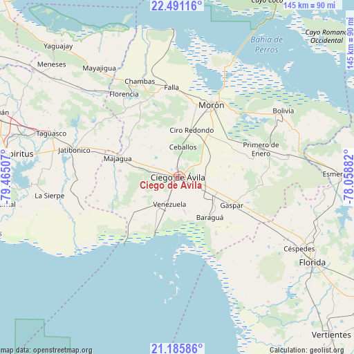
Ciego de Ávila GPS coordinates[2]
21° 50' 24" North, 78° 45' 42.984" West
| Map corner | latitude | longitude |
|---|---|---|
| Upper-left | 22.49116°, | -79.46507° |
| Center: | 21.84°, | -78.76194° |
| Lower-right: | 21.18586°, | -78.05882° |
| Map W x H: | 145.1×145.1 km | = 90.2×90.2mi |
| max Lat: | 23.15917° ⇑63% North |
| Ciego de Ávila: | 21.84° |
| min Lat: | ⇓37% South 19.90553° |
| min Long | Ciego de Ávila | max Long |
| -84.28599° | -78.76194° | -74.15181° |
| W 61.9%⇐ | ⇒38.1% E |
Elevation
Elevation of Ciego de Ávila is 49 m = 161 ft, and this is 19.6 m = 64 ft below average elevation for this country.
| Max E: |
761 m = 2497 ft | 52.5% |
| Avg. | 68.6 m = 225 ft | |
| Ciego de Ávila | 49 m = 161 ft | |
Min E: |
3 m = 10 ft | 47.5% |
See also: Ciego de Ávila elevation on elevation.city.
Geographical zone
Ciego de Ávila is located in North Torrid zone (between Equator and Tropic of Cancer). Distance of this Northern Tropic circle is 177.5 km =110.3 mi to North.| Distance of | km | miles | from Ciego de Ávila |
|---|---|---|---|
| North Pole | 7578.7 | 4709.2 | to North |
| Arctic Circle | 4972.8 | 3090 | to North |
| Tropic Cancer | 177.5 | 110.3 | to North |
| Equator | 2428.4 | 1508.9 | to South |


Nearby cities:
15 places around Ciego de Ávila: (largest is in red/bold)
• Baraguá
22.5 km =14 mi,  141°
141°
• Bolivia
51.4 km =31.9 mi,  58°
58°
• Carlos Manuel de Céspedes
57.6 km =35.8 mi,  120°
120°
• Chambas
42.4 km =26.3 mi,  338°
338°
• Ciro Redondo
20.8 km =12.9 mi,  16°
16°
• Florencia
40.4 km =25.1 mi,  327°
327°
• Gaspar
25.1 km =15.6 mi, 116°
• Jatibonico
43.5 km =27 mi,  285°
285°
• La Sierpe
52.8 km =32.8 mi,  261°
261°
• Majagua
26.3 km =16.3 mi, 289°
• Morón
32.9 km =20.4 mi,  25°
25°
• Primero de Enero
36.1 km =22.4 mi,  71°
71°
• Taguasco
54.8 km =34.1 mi, 289°
• Venezuela
11.9 km =7.4 mi,  195°
195°
• Zaza del Medio
64.8 km =40.3 mi, 285°
Sources, notices
• [Note1] Compared only with cities in Cuba existing in our database
• [Src1] Map data: © OpenStreetMap contributors (CC-BY-SA)
• [Src2] Other city data from geonames.org with taken over terms of usage.
• [Src3] Geographical zone / Annual Mean Temperature by Robert A. Rohde @ Wikipedia
