Florencia geodata
Florencia (Ciego de Ávila) is a seat of a second-order administrative division; located in Cuba in America/Havana (GMT-4) time zone. With population of 19,811 people, there are 109 cities with bigger population in this country. Compared to other cities in Cuba, 53.6% of cities are located further ↑North; 60.2% of cities are located further ←West and 79.6% of cities have lower elevation than Florencia. Note1


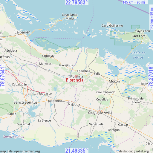
Florencia GPS coordinates[2]
22° 8' 45.96" North, 78° 58' 23.808" West
| Map corner | latitude | longitude |
|---|---|---|
| Upper-left | 22.79583°, | -79.67641° |
| Center: | 22.1461°, | -78.97328° |
| Lower-right: | 21.49335°, | -78.27016° |
| Map W x H: | 144.8×144.8 km | = 90×90mi |
| max Lat: | 23.15917° ⇑53.6% North |
| Florencia: | 22.1461° |
| min Lat: | ⇓46.4% South 19.90553° |
| min Long | Florencia | max Long |
| -84.28599° | -78.97328° | -74.15181° |
| W 60.2%⇐ | ⇒39.8% E |
Elevation
Elevation of Florencia is 98 m = 322 ft, and this is 29.4 m = 96 ft above average elevation for this country.
| Max E: |
761 m = 2497 ft | 20.4% |
| Florencia | 98 m 322 ft | |
| Avg. | 68.6 m = 225 ft | |
Min E: |
3 m = 10 ft | 79.6% |
See also: Cuba elevation on elevation.city.
Geographical zone
Florencia is located in North Torrid zone (between Equator and Tropic of Cancer). Distance of this Northern Tropic circle is 143.5 km =89.2 mi to North.| Distance of | km | miles | from Florencia |
|---|---|---|---|
| North Pole | 7544.6 | 4688 | to North |
| Arctic Circle | 4938.8 | 3068.8 | to North |
| Tropic Cancer | 143.5 | 89.2 | to North |
| Equator | 2462.4 | 1530.1 | to South |


Nearby cities:
15 places around Florencia: (largest is in red/bold)
• Cabaiguán
54.5 km =33.9 mi,  262°
262°
• Chambas
8.3 km =5.2 mi,  48°
48°
• Ciego de Ávila
40.4 km =25.1 mi,  147°
147°
• Ciro Redondo
31.2 km =19.4 mi,  116°
116°
• Guayos
51.4 km =31.9 mi, 257°
• Jatibonico
30.3 km =18.8 mi,  221°
221°
• La Sierpe
51.5 km =32 mi, 216°
• Majagua
25.6 km =15.9 mi,  186°
186°
• Morón
36 km =22.4 mi,  96°
96°
• Primero de Enero
60.2 km =37.4 mi,  111°
111°
• Sancti Spíritus
54 km =33.6 mi,  243°
243°
• Taguasco
34 km =21.1 mi, 241°
• Venezuela
49.1 km =30.5 mi,  157°
157°
• Yaguajay
33.7 km =20.9 mi,  306°
306°
• Zaza del Medio
43.8 km =27.2 mi,  247°
247°
Sources, notices
• [Note1] Compared only with cities in Cuba existing in our database
• [Src1] Map data: © OpenStreetMap contributors (CC-BY-SA)
• [Src2] Other city data from geonames.org with taken over terms of usage.
• [Src3] Geographical zone / Annual Mean Temperature by Robert A. Rohde @ Wikipedia
