Guanajay geodata
Guanajay (Artemisa) is a seat of a second-order administrative division; located in Cuba in America/Havana (GMT-4) time zone. With population of 25,258 people, there are 89 cities with bigger population in this country. Compared to other cities in Cuba, 84% of cities are located further ↓South; 89% of cities are located further →East and 84% of cities have lower elevation than Guanajay. Note1


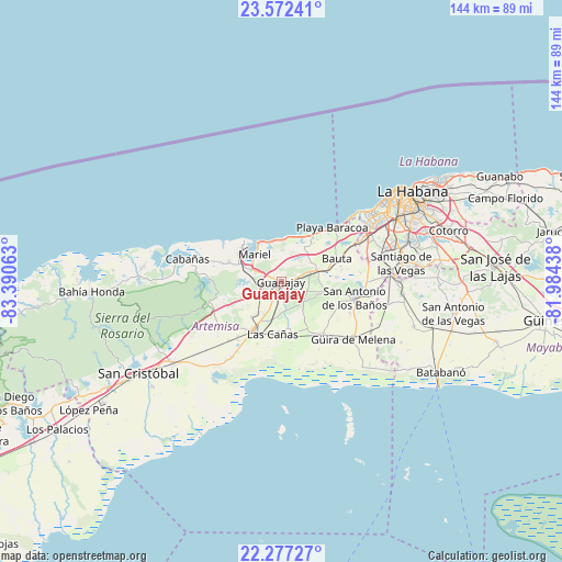
Guanajay GPS coordinates[2]
22° 55' 35.004" North, 82° 41' 15" West
| Map corner | latitude | longitude |
|---|---|---|
| Upper-left | 23.57241°, | -83.39063° |
| Center: | 22.92639°, | -82.6875° |
| Lower-right: | 22.27727°, | -81.98438° |
| Map W x H: | 144×144 km | = 89.5×89.5mi |
| max Lat: | 23.15917° ⇑16% North |
| Guanajay: | 22.92639° |
| min Lat: | ⇓84% South 19.90553° |
| min Long | Guanajay | max Long |
| -84.28599° | -82.6875° | -74.15181° |
| W 11%⇐ | ⇒89% E |
Elevation
Elevation of Guanajay is 109 m = 358 ft, and this is 40.4 m = 133 ft above average elevation for this country.
| Max E: |
761 m = 2497 ft | 16% |
| Guanajay | 109 m 358 ft | |
| Avg. | 68.6 m = 225 ft | |
Min E: |
3 m = 10 ft | 84% |
See also: Cuba elevation on elevation.city.
Geographical zone
Guanajay is located in North Torrid zone (between Equator and Tropic of Cancer). Distance of this Northern Tropic circle is 56.7 km =35.2 mi to North.| Distance of | km | miles | from Guanajay |
|---|---|---|---|
| North Pole | 7457.9 | 4634.1 | to North |
| Arctic Circle | 4852 | 3014.9 | to North |
| Tropic Cancer | 56.7 | 35.2 | to North |
| Equator | 2549.2 | 1584 | to South |


Nearby cities:
15 places around Guanajay: (largest is in red/bold)
• Alquízar
17.2 km =10.7 mi,  141°
141°
• Arroyo Naranjo
34.8 km =21.6 mi,  69°
69°
• Artemisa
14.3 km =8.9 mi,  211°
211°
• Bauta
15.7 km =9.8 mi, 66°
• Bejucal
30.6 km =19 mi,  89°
89°
• Boyeros
30.6 km =19 mi, 72°
• Cabañas
24.7 km =15.3 mi,  283°
283°
• Caimito
9.9 km =6.2 mi, 74°
• Candelaria
34.7 km =21.6 mi,  233°
233°
• Güira de Melena
23.5 km =14.6 mi,  128°
128°
• La Salud
27.7 km =17.2 mi,  102°
102°
• Mariel
9.7 km =6 mi,  315°
315°
• Quivicán
35.9 km =22.3 mi,  108°
108°
• San Antonio de los Baños
19.5 km =12.1 mi, 101°
• Santiago de las Vegas
31.2 km =19.4 mi,  81°
81°
Sources, notices
• [Note1] Compared only with cities in Cuba existing in our database
• [Src1] Map data: © OpenStreetMap contributors (CC-BY-SA)
• [Src2] Other city data from geonames.org with taken over terms of usage.
• [Src3] Geographical zone / Annual Mean Temperature by Robert A. Rohde @ Wikipedia
