Cabañas geodata
Cabañas (Artemisa) is a populated place; located in Cuba in America/Havana (GMT-4) time zone. With population of 5,894 people, there are 145 cities with bigger population in this country. Compared to other cities in Cuba, 89% of cities are located further ↓South; 91.2% of cities are located further →East and 97.8% of cities have higher elevation than Cabañas. Note1


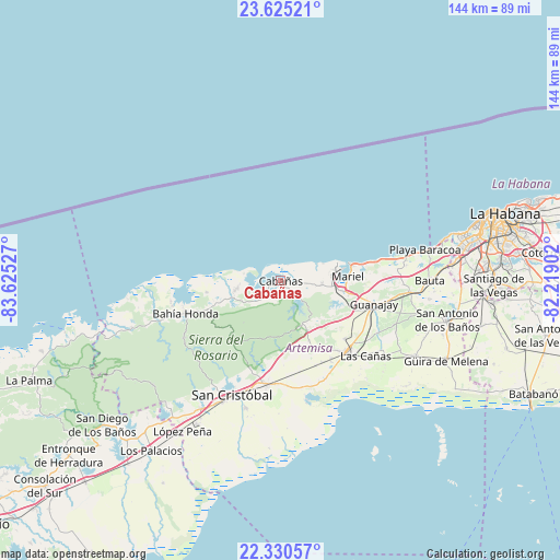
Cabañas GPS coordinates[2]
22° 58' 45.984" North, 82° 55' 19.704" West
| Map corner | latitude | longitude |
|---|---|---|
| Upper-left | 23.62521°, | -83.62527° |
| Center: | 22.97944°, | -82.92214° |
| Lower-right: | 22.33057°, | -82.21902° |
| Map W x H: | 144×144 km | = 89.5×89.5mi |
| max Lat: | 23.15917° ⇑11% North |
| Cabañas: | 22.97944° |
| min Lat: | ⇓89% South 19.90553° |
| min Long | Cabañas | max Long |
| -84.28599° | -82.92214° | -74.15181° |
| W 8.8%⇐ | ⇒91.2% E |
Elevation
Elevation of Cabañas is 7 m = 23 ft, and this is 61.6 m = 202 ft below average elevation for this country.
| Max E: |
761 m = 2497 ft | 97.8% |
| Avg. | 68.6 m = 225 ft | |
| Cabañas | 7 m = 23 ft | |
Min E: |
3 m = 10 ft | 2.2% |
See also: Cuba elevation on elevation.city.
Geographical zone
Cabañas is located in North Torrid zone (between Equator and Tropic of Cancer). Distance of this Northern Tropic circle is 50.8 km =31.6 mi to North.| Distance of | km | miles | from Cabañas |
|---|---|---|---|
| North Pole | 7452 | 4630.5 | to North |
| Arctic Circle | 4846.1 | 3011.2 | to North |
| Tropic Cancer | 50.8 | 31.6 | to North |
| Equator | 2555.1 | 1587.7 | to South |


Nearby cities:
15 places around Cabañas: (largest is in red/bold)
• Alquízar
39.7 km =24.7 mi,  119°
119°
• Artemisa
24.6 km =15.3 mi,  137°
137°
• Bahía Honda
25.8 km =16 mi,  250°
250°
• Bauta
38.4 km =23.9 mi,  89°
89°
• Boyeros
53.4 km =33.2 mi, 86°
• Caimito
33.7 km =20.9 mi,  95°
95°
• Candelaria
26.8 km =16.7 mi,  188°
188°
• Guanajay
24.7 km =15.3 mi, 103°
• Güira de Melena
47.2 km =29.3 mi, 115°
• La Salud
52.5 km =32.6 mi, 103°
• Los Palacios
54.7 km =34 mi,  217°
217°
• Mariel
17.3 km =10.7 mi, 86°
• San Antonio de los Baños
44.3 km =27.5 mi, 102°
• San Cristobal
32.3 km =20.1 mi,  205°
205°
• Soroa
22.2 km =13.8 mi, 205°
Sources, notices
• [Note1] Compared only with cities in Cuba existing in our database
• [Src1] Map data: © OpenStreetMap contributors (CC-BY-SA)
• [Src2] Other city data from geonames.org with taken over terms of usage.
• [Src3] Geographical zone / Annual Mean Temperature by Robert A. Rohde @ Wikipedia
