Artemisa geodata
Artemisa is a seat of a first-order administrative division; located in Cuba in America/Havana (GMT-4) time zone. With population of 68,073 people, there are 32 cities with bigger population in this country. Compared to other cities in Cuba, 79.6% of cities are located further ↓South; 90.1% of cities are located further →East and 51.9% of cities have lower elevation than Artemisa. Note1


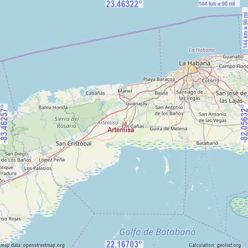
Artemisa GPS coordinates[2]
22° 49' 0.012" North, 82° 45' 33.984" West
| Map corner | latitude | longitude |
|---|---|---|
| Upper-left | 23.46322°, | -83.46257° |
| Center: | 22.81667°, | -82.75944° |
| Lower-right: | 22.16703°, | -82.05632° |
| Map W x H: | 144.1×144.1 km | = 89.5×89.5mi |
| max Lat: | 23.15917° ⇑20.4% North |
| Artemisa: | 22.81667° |
| min Lat: | ⇓79.6% South 19.90553° |
| min Long | Artemisa | max Long |
| -84.28599° | -82.75944° | -74.15181° |
| W 9.9%⇐ | ⇒90.1% E |
Elevation
Elevation of Artemisa is 54 m = 177 ft, and this is 14.6 m = 48 ft below average elevation for this country.
| Max E: |
761 m = 2497 ft | 48.1% |
| Avg. | 68.6 m = 225 ft | |
| Artemisa | 54 m = 177 ft | |
Min E: |
3 m = 10 ft | 51.9% |
See also: Artemisa elevation on elevation.city.
Geographical zone
Artemisa is located in North Torrid zone (between Equator and Tropic of Cancer). Distance of this Northern Tropic circle is 68.9 km =42.8 mi to North.| Distance of | km | miles | from Artemisa |
|---|---|---|---|
| North Pole | 7470.1 | 4641.7 | to North |
| Arctic Circle | 4864.2 | 3022.5 | to North |
| Tropic Cancer | 68.9 | 42.8 | to North |
| Equator | 2537 | 1576.4 | to South |


Nearby cities:
15 places around Artemisa: (largest is in red/bold)
• Alquízar
18 km =11.2 mi,  94°
94°
• Bauta
28.5 km =17.7 mi,  49°
49°
• Bejucal
40 km =24.9 mi,  71°
71°
• Cabañas
24.6 km =15.3 mi,  317°
317°
• Caimito
22.5 km =14 mi, 48°
• Candelaria
22.2 km =13.8 mi,  247°
247°
• Guanajay
14.3 km =8.9 mi,  31°
31°
• Güira de Melena
26 km =16.2 mi,  95°
95°
• La Salud
35 km =21.7 mi,  79°
79°
• Mariel
19.2 km =11.9 mi,  1°
1°
• Quivicán
41.4 km =25.7 mi, 89°
• San Antonio de los Baños
27.7 km =17.2 mi, 72°
• San Cristobal
32.4 km =20.1 mi, 249°
• Santiago de las Vegas
41.8 km =26 mi, 65°
• Soroa
26.4 km =16.4 mi,  265°
265°
Sources, notices
• [Note1] Compared only with cities in Cuba existing in our database
• [Src1] Map data: © OpenStreetMap contributors (CC-BY-SA)
• [Src2] Other city data from geonames.org with taken over terms of usage.
• [Src3] Geographical zone / Annual Mean Temperature by Robert A. Rohde @ Wikipedia
